IMAGES TAKEN NEAR TO
Blagdens Close, LONDON, N14 6DE
Introduction
This page details the photographs taken nearby to Blagdens Close, N14 6DE by members of the Geograph project.
The Geograph project started in 2005 with the aim of publishing, organising and preserving representative images for every square kilometre of Great Britain, Ireland and the Isle of Man.

There are currently over 7.5m images from over14,400 individuals and you can help contribute to the project by visiting https://www.geograph.org.uk
Image Map
Images are licensed for reuse under creativecommons.org/licenses/by-sa/2.0
Notes
- Clicking on the map will re-center to the selected point.
- The higher the marker number, the further away the image location is from the centre of the postcode.
Image Listing (100 Images Found)
Images are licensed for reuse under creativecommons.org/licenses/by-sa/2.0
Image
Details
Distance
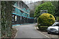

5
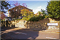
Blagdens Lane, London N14
Looking down Blagdens Lane. Bramford Court can just be seen on the left.
Image: © Christine Matthews
Taken: 8 Oct 2008
0.11 miles
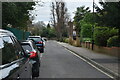
6

Wall by the High Street, London N14
Image: © Christine Matthews
Taken: 24 Feb 2018
0.12 miles
7
Wall by the High Street, London N14
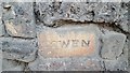
Word on brickwork - COWEN.
Image: © Christine Matthews
Taken: 24 Feb 2018
0.12 miles
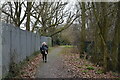
9
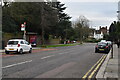
Junction of Blagdens Lane with High Street, London N14
Junction of Blagdens Lane with the High Street looking towards Southgate Station.
Image: © Christine Matthews
Taken: 8 Oct 2008
0.13 miles
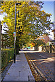
10
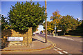
Blagdens Lane, London N14
Georgian house on corner of Blagdens Lane and the High Street.
Image: © Christine Matthews
Taken: 8 Oct 2008
0.13 miles