IMAGES TAKEN NEAR TO
Shamrock Way, LONDON, N14 5RY
Introduction
This page details the photographs taken nearby to Shamrock Way, N14 5RY by members of the Geograph project.
The Geograph project started in 2005 with the aim of publishing, organising and preserving representative images for every square kilometre of Great Britain, Ireland and the Isle of Man.

There are currently over 7.5m images from over14,400 individuals and you can help contribute to the project by visiting https://www.geograph.org.uk
Image Map
Images are licensed for reuse under creativecommons.org/licenses/by-sa/2.0
Notes
- Clicking on the map will re-center to the selected point.
- The higher the marker number, the further away the image location is from the centre of the postcode.
Image Listing (67 Images Found)
Images are licensed for reuse under creativecommons.org/licenses/by-sa/2.0
Image
Details
Distance
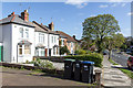
2
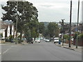
Victorian Semi-Detached Houses in Avenue Road, London N14
Image: © Christine Matthews
Taken: 13 Apr 2014
0.08 miles
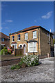
3
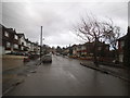
Small Terrace of Houses in Avenue Road, London N14
Image: © Christine Matthews
Taken: 13 Apr 2014
0.08 miles
5

Old sign for Hampden Square shop numbers
One of four around the square with different names
Image: © David Howard
Taken: 27 Sep 2013
0.10 miles
8
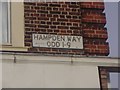
Road sign for Hampden Way
With added information, there's another around the building
Image: © David Howard
Taken: 25 Sep 2013
0.10 miles
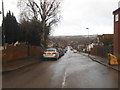
10
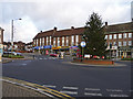
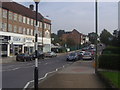
Hampden Square, London N14
Looking north up Hampden Square from the corner of Osidge Lane.
Image: © Christine Matthews
Taken: 9 Dec 2008
0.11 miles