IMAGES TAKEN NEAR TO
Cedar Rise, LONDON, N14 5NH
Introduction
This page details the photographs taken nearby to Cedar Rise, N14 5NH by members of the Geograph project.
The Geograph project started in 2005 with the aim of publishing, organising and preserving representative images for every square kilometre of Great Britain, Ireland and the Isle of Man.

There are currently over 7.5m images from over14,400 individuals and you can help contribute to the project by visiting https://www.geograph.org.uk
Image Map
Images are licensed for reuse under creativecommons.org/licenses/by-sa/2.0
Notes
- Clicking on the map will re-center to the selected point.
- The higher the marker number, the further away the image location is from the centre of the postcode.
Image Listing (69 Images Found)
Images are licensed for reuse under creativecommons.org/licenses/by-sa/2.0
Image
Details
Distance
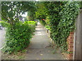
1
Monkfrith Close, London N14
Monkfrith Close is a cul-de-sac off Monkfrith Way.
Image: © Christine Matthews
Taken: 9 Apr 2010
0.04 miles
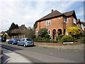
3
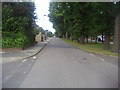
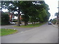
Monkfrith Way, London N14
Monkfrith Way is a wide road with a green and trees in the middle.
Image: © Christine Matthews
Taken: 9 Apr 2010
0.06 miles
4
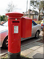
George V Pillar Box, Oak Way, London N14
Situated just round the corner from Monkfrith Way.
Image: © Christine Matthews
Taken: 9 Apr 2010
0.06 miles
6
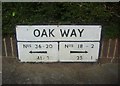
Street name with numbers on Oak Way, Southgate
One of a pair
Image: © David Howard
Taken: 27 Sep 2013
0.07 miles
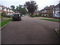
9
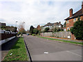
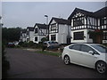
Friars Walk, London N14
As seen from Monkfrith Way.
Image: © Christine Matthews
Taken: 9 Apr 2010
0.07 miles