IMAGES TAKEN NEAR TO
Crown Lane, LONDON, N14 5HB
Introduction
This page details the photographs taken nearby to Crown Lane, N14 5HB by members of the Geograph project.
The Geograph project started in 2005 with the aim of publishing, organising and preserving representative images for every square kilometre of Great Britain, Ireland and the Isle of Man.

There are currently over 7.5m images from over14,400 individuals and you can help contribute to the project by visiting https://www.geograph.org.uk
Image Map
Images are licensed for reuse under creativecommons.org/licenses/by-sa/2.0
Notes
- Clicking on the map will re-center to the selected point.
- The higher the marker number, the further away the image location is from the centre of the postcode.
Image Listing (239 Images Found)
Images are licensed for reuse under creativecommons.org/licenses/by-sa/2.0
Image
Details
Distance
1
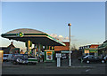
BP Petrol Station on corner of Chase Side and Chase Way, N14
One of the new solar powered BP Petrol Stations and mini supermarket and cafe, on corner of Chase Side and Chase.
Image: © Christine Matthews
Taken: 6 Feb 2007
0.06 miles
2
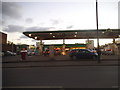
BP petrol station on Chase Side, Southgate
Image: © David Howard
Taken: 6 Feb 2015
0.07 miles
4
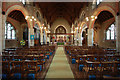
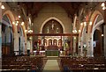
St Andrew, Chase Side, Southgate - East end
Image: © John Salmon
Taken: 15 Jul 2011
0.08 miles
5
St Andrew, Chase Side, Southgate - East end
Image: © John Salmon
Taken: 15 Jul 2011
0.08 miles
6
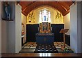
St Andrew, Chase Side, Southgate - North chapel
Image: © John Salmon
Taken: 15 Jul 2011
0.08 miles
7
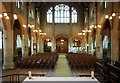
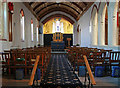
St Andrew, Chase Side, Southgate - West end
Image: © John Salmon
Taken: 15 Jul 2011
0.08 miles
8
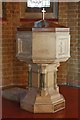
St Andrew, Chase Side, Southgate - Font
Image: © John Salmon
Taken: 15 Jul 2011
0.08 miles
9
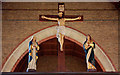
St Andrew, Chase Side, Southgate - Rood
Image: © John Salmon
Taken: 15 Jul 2011
0.08 miles
10
St Andrew, Chase Side, Southgate - North chapel
Image: © John Salmon
Taken: 15 Jul 2011
0.08 miles