IMAGES TAKEN NEAR TO
Ashfield Parade, LONDON, N14 5EH
Introduction
This page details the photographs taken nearby to Ashfield Parade, N14 5EH by members of the Geograph project.
The Geograph project started in 2005 with the aim of publishing, organising and preserving representative images for every square kilometre of Great Britain, Ireland and the Isle of Man.

There are currently over 7.5m images from over14,400 individuals and you can help contribute to the project by visiting https://www.geograph.org.uk
Image Map
Images are licensed for reuse under creativecommons.org/licenses/by-sa/2.0
Notes
- Clicking on the map will re-center to the selected point.
- The higher the marker number, the further away the image location is from the centre of the postcode.
Image Listing (316 Images Found)
Images are licensed for reuse under creativecommons.org/licenses/by-sa/2.0
Image
Details
Distance
1
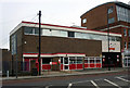
Southgate Royal Mail Delivery Office (1963)
Tyoical 1960s utilitarian post office architecture.
Image: © Jim Osley
Taken: 4 Dec 2011
0.01 miles
2
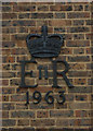
Elizabeth II cypher, Southgate Delivery Office
Over the years it has been common, although not universal practice, to display the Royal cypher on public service buildings - very useful for local and architectural historians!
Image: © Jim Osley
Taken: 4 Dec 2011
0.01 miles
3
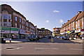
Ashfield Parade, London N14
Looking across towards Ashfield Parade from Crown Lane. Ashfield Parade was formerly called Ashfield Road.
Image: © Christine Matthews
Taken: 8 Oct 2008
0.02 miles
4
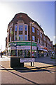
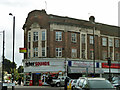
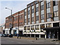
Building on corner Ashfield Parade and High Street, London N14
This imposing building on the corner of Ashfield Parade and the High Street was originally a small departmental store called B. Davis. To the best of my recollection it was an estate agent, then a Property Bureau (dealing mainly with lettings). I believe the company went out of business and it is now empty.
Image: © Christine Matthews
Taken: 8 Oct 2008
0.02 miles
5
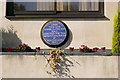
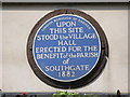
Blue Plaque marking the site of Southgate Village Hall, London N14
Blue plaque commemorating the position where the Village Hall was erected in 1882 for the benefit of the parish of Southgate.
Image: © Christine Matthews
Taken: 8 Oct 2008
0.02 miles
6
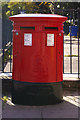
Double Elizabeth II Pillar Box, High Street, London N14
This Elizabeth II pillar box is outside the Sorting Office in the High Street.
Image: © Christine Matthews
Taken: 8 Oct 2008
0.02 miles
7
Ashfield Parade, Southgate
The road to the right is Ashfield Parade, formerly Ashfield Road, and has shops on each side. The pictured shops extend a little way around the corner to the left along the High Street.
Image: © Robin Webster
Taken: 25 Nov 2012
0.02 miles
8
Blue plaque re Southgate Village Hall
The location of this blue plaque is shown in Image
Image: © Mike Quinn
Taken: 12 May 2009
0.02 miles
9
Offices in the High Street, N14
Shows the location of Image
Image: © Mike Quinn
Taken: 12 May 2009
0.02 miles
10
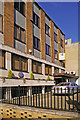
Building in High Street, London N14
Office building in the High Street with blue plaque Image] commemorating the site of the village hall erected in 1882 for the benefit of the parish of Southgate. I believe this part of Southgate suffered some bomb damage in WW2 and these buildings and the Technical College were built on the site.
Image: © Christine Matthews
Taken: 8 Oct 2008
0.03 miles