IMAGES TAKEN NEAR TO
Burleigh Gardens, LONDON, N14 5AN
Introduction
This page details the photographs taken nearby to Burleigh Gardens, N14 5AN by members of the Geograph project.
The Geograph project started in 2005 with the aim of publishing, organising and preserving representative images for every square kilometre of Great Britain, Ireland and the Isle of Man.

There are currently over 7.5m images from over14,400 individuals and you can help contribute to the project by visiting https://www.geograph.org.uk
Image Map
Images are licensed for reuse under creativecommons.org/licenses/by-sa/2.0
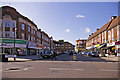
Notes
- Clicking on the map will re-center to the selected point.
- The higher the marker number, the further away the image location is from the centre of the postcode.
Image Listing (335 Images Found)
Images are licensed for reuse under creativecommons.org/licenses/by-sa/2.0
Image
Details
Distance
1
Ashfield Parade, London N14
Looking across towards Ashfield Parade from Crown Lane. Ashfield Parade was formerly called Ashfield Road.
Image: © Christine Matthews
Taken: 8 Oct 2008
0.01 miles
2
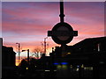
Sunrise over Southgate Tube Station
Taken on 27th November 2001 at 7:23am
Image: © Julian Shulman
Taken: 27 Nov 2001
0.02 miles
3
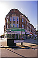
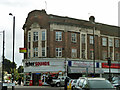
Building on corner Ashfield Parade and High Street, London N14
This imposing building on the corner of Ashfield Parade and the High Street was originally a small departmental store called B. Davis. To the best of my recollection it was an estate agent, then a Property Bureau (dealing mainly with lettings). I believe the company went out of business and it is now empty.
Image: © Christine Matthews
Taken: 8 Oct 2008
0.02 miles
4
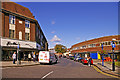
Crown Lane, London N14
Crown Lane as seen from the traffic island. The back of Station Parade can be seen on the right and a menswear shop on the left. Note all the pigeons sitting on top of the building on the right. Resourceful birds, they're kept off the station and the lamps by wires, but they still find somewhere else!
Image: © Christine Matthews
Taken: 8 Oct 2008
0.04 miles
5
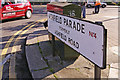
Road sign, Ashfield Parade, London N14
Road sign for Ashfield Parade looking towards the High Street.
Image: © Christine Matthews
Taken: 8 Oct 2008
0.04 miles
6
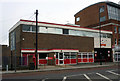
Southgate Royal Mail Delivery Office (1963)
Tyoical 1960s utilitarian post office architecture.
Image: © Jim Osley
Taken: 4 Dec 2011
0.04 miles
7
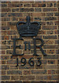
Elizabeth II cypher, Southgate Delivery Office
Over the years it has been common, although not universal practice, to display the Royal cypher on public service buildings - very useful for local and architectural historians!
Image: © Jim Osley
Taken: 4 Dec 2011
0.04 miles
8
Ashfield Parade, Southgate
The road to the right is Ashfield Parade, formerly Ashfield Road, and has shops on each side. The pictured shops extend a little way around the corner to the left along the High Street.
Image: © Robin Webster
Taken: 25 Nov 2012
0.04 miles
9
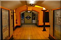
Southgate underground station
This view is from the southbound platform, looking across the hall at the foot of the escalators to the northbound platform and the wall beyond it. Note the Art Deco uplighter: a particular feature of underground stations either built, like this one, or refurbished in the inter-war years.
Image: © Christopher Hilton
Taken: 17 Aug 2017
0.04 miles
10
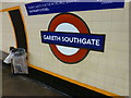
Why wasn't he called Gareth Knightsbridge?
If Southgate Station had been in Zone 1 - like Knightsbridge for example - I wouldn't have had to fork out £13.50 in Tube fares to take a random photo of a temporary sign! Still, if he was called Gareth Amersham that really would have been expensive!
Wonder if the man himself has taken a selfie here? You are spared the selfie I took purely as it has no geographical content apart from a furrowed brow!
Image: © Ian Paterson
Taken: 17 Jul 2018
0.05 miles