IMAGES TAKEN NEAR TO
Sheringham Avenue, LONDON, N14 4UB
Introduction
This page details the photographs taken nearby to Sheringham Avenue, N14 4UB by members of the Geograph project.
The Geograph project started in 2005 with the aim of publishing, organising and preserving representative images for every square kilometre of Great Britain, Ireland and the Isle of Man.

There are currently over 7.5m images from over14,400 individuals and you can help contribute to the project by visiting https://www.geograph.org.uk
Image Map
Images are licensed for reuse under creativecommons.org/licenses/by-sa/2.0
Notes
- Clicking on the map will re-center to the selected point.
- The higher the marker number, the further away the image location is from the centre of the postcode.
Image Listing (1199 Images Found)
Images are licensed for reuse under creativecommons.org/licenses/by-sa/2.0
Image
Details
Distance
1
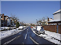
Sheringham Avenue, London N14
Looking down Sheringham Avenue from close by the roundabout at the crossroads with Merrivale. The spire of St Thomas's Church can be seen.
Image: © Christine Matthews
Taken: 3 Feb 2009
0.02 miles
2
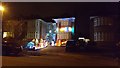
House Opposite St Thomas, London N14
Plenty of decorations on this house.
Image: © Christine Matthews
Taken: 25 Dec 2016
0.02 miles
3
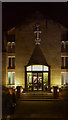
Midnight Service, St Thomas, London N14
Image: © Christine Matthews
Taken: 24 Dec 2016
0.02 miles
4
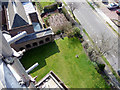
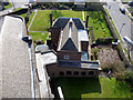
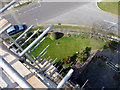
Church Garden, St Thomas's, London N14
Looking down from the spire of the church. Sheringham Avenue can be seen to the right. I can also be seen standing in the garden!
Image: © A. Steeplejack
Taken: 21 Mar 2012
0.02 miles
5
Church Roof and Vicarage, St Thomas's, London N14
As seen from the spire. I can be seen standing in the garden!
Image: © A. Steeplejack
Taken: 21 Mar 2012
0.02 miles
6
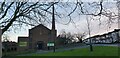
St Thomas's Church, Prince George Avenue, London N14
The building of this church commenced in the 1930s when the Piccadilly Line was extended to Cockfosters. Building work ceased during WW2 with the church being finished in the 1950s when the copper spire was added to the building. This blew down in a gale in I think the 1960s. The replacement was taken down a few years ago as the wood inside had rotted. It was replaced with what you can see in this photograph.
Image: © Christine Matthews
Taken: 12 Jan 2021
0.02 miles
7
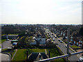
Sheringham Avenue, London N14
Looking down from the spire of St Thomas's Church. The garden of the church can be seen in the image.
Image: © A. Steeplejack
Taken: 21 Mar 2012
0.03 miles
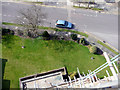
8
Sheringham Avenue, London N14
As seen from the spire of St Thomas's Church. The roof of the vicarage and the vicarage garden can be seen at the base of the image.
Image: © A. Steeplejack
Taken: 21 Mar 2012
0.03 miles
9
Church Entrance and Garden, St Thomas's, London N14
As seen from the spire.
Image: © A. Steeplejack
Taken: 21 Mar 2012
0.03 miles
10
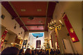
St Thomas's Church, London N14
Candlelit service for midnight mass.
Image: © Christine Matthews
Taken: 24 Dec 2013
0.03 miles