IMAGES TAKEN NEAR TO
Ivy Road, LONDON, N14 4LN
Introduction
This page details the photographs taken nearby to Ivy Road, N14 4LN by members of the Geograph project.
The Geograph project started in 2005 with the aim of publishing, organising and preserving representative images for every square kilometre of Great Britain, Ireland and the Isle of Man.

There are currently over 7.5m images from over14,400 individuals and you can help contribute to the project by visiting https://www.geograph.org.uk
Image Map
Images are licensed for reuse under creativecommons.org/licenses/by-sa/2.0
Notes
- Clicking on the map will re-center to the selected point.
- The higher the marker number, the further away the image location is from the centre of the postcode.
Image Listing (114 Images Found)
Images are licensed for reuse under creativecommons.org/licenses/by-sa/2.0
Image
Details
Distance
1
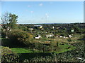
View looking north from Asda Carpark, Southgate
Looking north out of the Asda Carpark in Southgate you can see across the allotments, over Oakwood to the hills in the countryside in the distance
Image: © Christine Matthews
Taken: 20 Oct 2005
0.11 miles
2
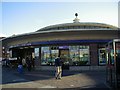
Southgate Underground Station
Opened in 1933, this station building by architect Charles Holden was designed to be a feature of the area incorporating some small shops.
Image: © Hywel Williams
Taken: 11 Oct 2000
0.12 miles
3
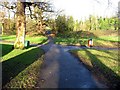
Oakwood Park, London N14
Paths in the park
Image: © John Salmon
Taken: 30 Dec 2006
0.13 miles
4
Chase Road, London N14
Looking down Chase Road towards Oakwood from near the junction with Hillside Grove.
Image: © Christine Matthews
Taken: 25 Dec 2008
0.13 miles
5
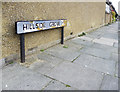
Road sign Hillside Grove, London N14
More recent road sign, though the white paint is peeling off and it is starting to go yellow like some of the sign posts have done in this area.
Image: © Christine Matthews
Taken: 25 Dec 2008
0.15 miles
6
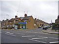
Chaseside Food Wine store, Chase Road, London N14 - Christmas Day 2008
One of the few shops which was opening. When I was there at 12.08pm there were no customers.
Image: © Christine Matthews
Taken: 25 Dec 2008
0.16 miles
7

Flowerbed and sitting area near St Andrew's Church, Chase Side, London N14
Adjacent to St Andrew's Church between the west wall of the church and the entrance to ASDA, is the flowerbed and sitting area. The houses in Chelmsford Road can be seen on the left.
Image: © Christine Matthews
Taken: 8 Oct 2008
0.17 miles
8
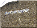
Road sign, Hillside Grove, London N14
Original road sign on the side wall of what is now the Chaseside Store on the corner of Chase Road and Hillside Grove.
Image: © Christine Matthews
Taken: 25 Dec 2008
0.17 miles
9

West wall of St Andrew's Church, Chase Side, London N14
West wall of St Andrew's Church as seen from the pathway to ASDA.
Image: © Christine Matthews
Taken: 8 Oct 2008
0.17 miles
10
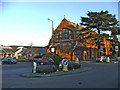
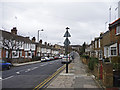
St Andrew's Parish Church, Chase Side, Southgate, N14
St Andrew's Parish Church Southgate taken from the roundabout junction of Chase Side and Chase Way.
Image: © Christine Matthews
Taken: 6 Feb 2007
0.17 miles