IMAGES TAKEN NEAR TO
Essex Road, LONDON, N1 3AY
Introduction
This page details the photographs taken nearby to Essex Road, N1 3AY by members of the Geograph project.
The Geograph project started in 2005 with the aim of publishing, organising and preserving representative images for every square kilometre of Great Britain, Ireland and the Isle of Man.

There are currently over 7.5m images from over14,400 individuals and you can help contribute to the project by visiting https://www.geograph.org.uk
Image Map
Images are licensed for reuse under creativecommons.org/licenses/by-sa/2.0
Notes
- Clicking on the map will re-center to the selected point.
- The higher the marker number, the further away the image location is from the centre of the postcode.
Image Listing (186 Images Found)
Images are licensed for reuse under creativecommons.org/licenses/by-sa/2.0
Image
Details
Distance
1
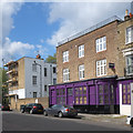
Former public house, Rotherfield Street
The image shows the former "Duke of Clarence" public which closed in 2006, and subsequently converted into residential accommodation.
Image: © Jim Osley
Taken: 28 Apr 2017
0.01 miles
2
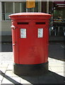
Double aperture Elizabeth II postbox on Essex Road, London N1
Outside the Post Office.
Postboxes Nos. N1 90 and N1 190.
See Image] for context.
Image: © JThomas
Taken: 5 Aug 2017
0.01 miles
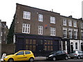
3
Essex Road Post Office, London N1
Showing position of Postboxes Nos. N1 90 and N1 190.
See Image] for postbox.
Image: © JThomas
Taken: 5 Aug 2017
0.01 miles
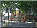
4
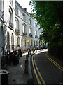
Essex Road, Islington
Looking along this stretch of Essex Road where the shops are separated from the main carriageway by a service road. The post box stands outside Essex Road Post Office.
Image: © Stephen McKay
Taken: 28 Apr 2011
0.01 miles
6
Former Duke of Clarence pub, Islington
This former pub is on Rotherfield Street, now converted into flats.
Image: © David Anstiss
Taken: 3 Feb 2013
0.02 miles
7
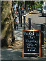
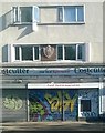
Essex Road, Islington
Along this stretch of Essex Road, close to the junction with New North Road, a row of shops is separated from the main carriageway by a service road; one of the shops is tempting passers-by with some mouth-watering treats.
Image: © Stephen McKay
Taken: 28 Apr 2011
0.02 miles
8
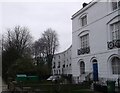
Annette Crescent, Islington
A row of Grade II listed terraced houses (Nos.246 - 290). No.290 is on the right. They surround a semi-circular garden on Essex Road.
See http://www.britishlistedbuildings.co.uk/en-368883-annette-crescent-and-attached-railings-g for more details about the terrace.
Image: © David Anstiss
Taken: 3 Feb 2013
0.03 miles
9

Canonbury Street
Part of the small district called Canonbury, a name going back to the 13th century.
Wikipedia says "In 1253 land in the area was granted to the Canons of St Bartholomew’s Priory, Smithfield and became known as Canonbury"
Image: © Des Blenkinsopp
Taken: 24 Jul 2016
0.03 miles
10
Flats and shops on Essex Road, Islington
The coat of arms is that of the Metropolitan Borough of Islington (1900-1965), which became part of the modern London Borough of Islington (1965-present). See https://en.wikipedia.org/wiki/Metropolitan_Borough_of_Islington#/media/File:Islington_Arms.JPG for a clearer image of the arms.
Image: © Christopher Hilton
Taken: 14 Sep 2016
0.04 miles