IMAGES TAKEN NEAR TO
Tottenhall Road, LONDON, N13 6JB
Introduction
This page details the photographs taken nearby to Tottenhall Road, N13 6JB by members of the Geograph project.
The Geograph project started in 2005 with the aim of publishing, organising and preserving representative images for every square kilometre of Great Britain, Ireland and the Isle of Man.

There are currently over 7.5m images from over14,400 individuals and you can help contribute to the project by visiting https://www.geograph.org.uk
Image Map
Images are licensed for reuse under creativecommons.org/licenses/by-sa/2.0
Notes
- Clicking on the map will re-center to the selected point.
- The higher the marker number, the further away the image location is from the centre of the postcode.
Image Listing (4 Images Found)
Images are licensed for reuse under creativecommons.org/licenses/by-sa/2.0
Image
Details
Distance
1

Development behind 260-282 North Circular Road
Image: © Alex McGregor
Taken: 20 Aug 2014
0.17 miles
2
Upsdell Ave
This is a long residential street off Green Lanes consisting mainly of terraced houses.. It has Grenoble Gardens to the south of it and Berkshire Gardens to the north.
Image: © Nigel Mykura
Taken: 7 Jun 2015
0.22 miles
3

North Circular Road westbound, Palmers Green
Just before the junction with Green Lanes, the Clockhouse Junction, the name of the parade and one of the shops on the other side.
Image: © David Howard
Taken: 27 Aug 2008
0.23 miles
4

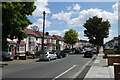
Green Lanes, London N13 (A105)
Looking south down Green Lanes towards Wood Green.
Image: © Christine Matthews
Taken: 11 Mar 2009
0.24 miles