IMAGES TAKEN NEAR TO
Thetford Close, LONDON, N13 6AT
Introduction
This page details the photographs taken nearby to Thetford Close, N13 6AT by members of the Geograph project.
The Geograph project started in 2005 with the aim of publishing, organising and preserving representative images for every square kilometre of Great Britain, Ireland and the Isle of Man.

There are currently over 7.5m images from over14,400 individuals and you can help contribute to the project by visiting https://www.geograph.org.uk
Image Map
Images are licensed for reuse under creativecommons.org/licenses/by-sa/2.0
Notes
- Clicking on the map will re-center to the selected point.
- The higher the marker number, the further away the image location is from the centre of the postcode.
Image Listing (16 Images Found)
Images are licensed for reuse under creativecommons.org/licenses/by-sa/2.0
Image
Details
Distance
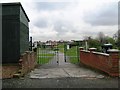
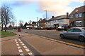
1

St George's Industrial Estate, Tottenham
Image: © David Howard
Taken: 23 Jan 2021
0.14 miles
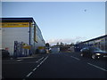
4

The entrance to St George's Industrial Estate, Tottenham
Image: © David Howard
Taken: 23 Jan 2021
0.15 miles

7
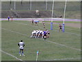
Scrum Down at New River Stadium, White Hart Lane
Image: © Michael Steele
Taken: 14 Feb 2010
0.16 miles
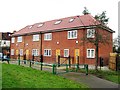
8
Retail units off White Hart Lane, Tottenham
These replaced the previous building in 2012
Image: © David Howard
Taken: 7 Jan 2014
0.17 miles
9

Retail units off White Hart Lane, Tottenham
These replaced the previous building in 2012
Image: © David Howard
Taken: 7 Jan 2014
0.19 miles
10
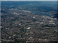
Edmonton and the Lea Valley reservoirs from the air
The three largest of the thirteen reservoirs within the Lea Valley complex https://en.wikipedia.org/wiki/Lee_Valley_Reservoir_Chain .
Image: © Thomas Nugent
Taken: 22 Jun 2015
0.22 miles