IMAGES TAKEN NEAR TO
Mia Mews, LONDON, N13 6AQ
Introduction
This page details the photographs taken nearby to Mia Mews, N13 6AQ by members of the Geograph project.
The Geograph project started in 2005 with the aim of publishing, organising and preserving representative images for every square kilometre of Great Britain, Ireland and the Isle of Man.

There are currently over 7.5m images from over14,400 individuals and you can help contribute to the project by visiting https://www.geograph.org.uk
Image Map
Images are licensed for reuse under creativecommons.org/licenses/by-sa/2.0
Notes
- Clicking on the map will re-center to the selected point.
- The higher the marker number, the further away the image location is from the centre of the postcode.
Image Listing (60 Images Found)
Images are licensed for reuse under creativecommons.org/licenses/by-sa/2.0
Image
Details
Distance
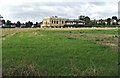
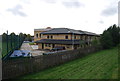
1

Development behind 260-282 North Circular Road
Image: © Alex McGregor
Taken: 20 Aug 2014
0.01 miles
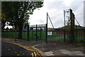
2
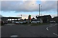
Oakthorpe Road at the junction of the North Circular Road
Image: © David Howard
Taken: 17 Mar 2021
0.10 miles
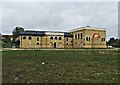
4
Mosque, Oakthorpe Road, Palmers Green
Another view of the Mosque in Oakthorpe Road, this time seen from Chimes Avenue.
Image: © Christine Matthews
Taken: 14 Sep 2005
0.14 miles

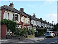
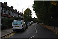
9
Mosque, Oakthorpe Road, Palmers Green
Mosque in Oakthorpe Road taken from Oakthorpe Road.
Image: © Christine Matthews
Taken: 14 Sep 2005
0.16 miles