IMAGES TAKEN NEAR TO
Regents Avenue, LONDON, N13 5UR
Introduction
This page details the photographs taken nearby to Regents Avenue, N13 5UR by members of the Geograph project.
The Geograph project started in 2005 with the aim of publishing, organising and preserving representative images for every square kilometre of Great Britain, Ireland and the Isle of Man.

There are currently over 7.5m images from over14,400 individuals and you can help contribute to the project by visiting https://www.geograph.org.uk
Image Map
Images are licensed for reuse under creativecommons.org/licenses/by-sa/2.0
Notes
- Clicking on the map will re-center to the selected point.
- The higher the marker number, the further away the image location is from the centre of the postcode.
Image Listing (109 Images Found)
Images are licensed for reuse under creativecommons.org/licenses/by-sa/2.0
Image
Details
Distance
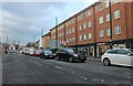
1

North Circular Road westbound, Palmers Green
Just before the junction with Green Lanes, the Clockhouse Junction, the name of the parade and one of the shops on the other side.
Image: © David Howard
Taken: 27 Aug 2008
0.03 miles
3
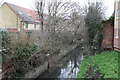
Pymmes Brook
Enclosed by a concrete channel, the brook is no longer free to wander as it passes under Green Lanes.
Image: © Martin Addison
Taken: 20 Jan 2012
0.08 miles
4
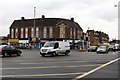
A105 Green Lanes
The traffic streams across the A406 North Circular at this busy junction. The road layout has been changed to improve traffic flow along the A406 at this well known bottleneck.
Image: © Martin Addison
Taken: 20 Jan 2012
0.08 miles
5

Bowes Road at the junction of Green Lanes
Image: © David Howard
Taken: 5 Jan 2012
0.09 miles
6

North Circular Road
The A406 North Circular Road, approaching Palmers Green from the west. The tree and grassy area in the foreground are between the eastbound and westbound carriageways.
Image: © Malc McDonald
Taken: 23 May 2010
0.09 miles
7
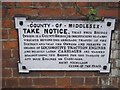
Old sign on Pymmes Brook bridge, Green Lanes
This has not only survived but been repainted quite recently. Originally these signs were not issued nationally as they were after the 1930s, but individually by local councils, this being an official county bridge as well. Interestingly although some were located facing the traffic many like this were set on the bridge itself, meaning most of the little traffic passing in those days may well not notice them. And they would certainly have needed to stop to read them as the print is far too small to read while moving.
Image: © David Howard
Taken: 16 Oct 2014
0.10 miles
8
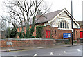
Palmers Green Baptist Church
Located on Green Lanes beside Pymmes Brook. The building was erected in 1905. The doors have acquired a coat of red paint and some of the letters have fallen off since it was last photographed in 2010!
Image: © Martin Addison
Taken: 20 Jan 2012
0.10 miles
9
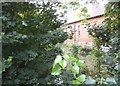
Pymmes Brook by Green Lanes, Palmers Green
Palmers Green Baptist Church is on the right, the brook is the other side of the trees.
Image: © David Howard
Taken: 16 Oct 2014
0.11 miles
10

Houses on Bowes Road, Palmers Green
The stretch of road from here back to Bounds Green Road has been widened and modernised, although besides the new island this part has not changed as much as the rest.
Image: © David Howard
Taken: 31 Jan 2012
0.12 miles