IMAGES TAKEN NEAR TO
Oakthorpe Road, LONDON, N13 5TY
Introduction
This page details the photographs taken nearby to Oakthorpe Road, N13 5TY by members of the Geograph project.
The Geograph project started in 2005 with the aim of publishing, organising and preserving representative images for every square kilometre of Great Britain, Ireland and the Isle of Man.

There are currently over 7.5m images from over14,400 individuals and you can help contribute to the project by visiting https://www.geograph.org.uk
Image Map
Images are licensed for reuse under creativecommons.org/licenses/by-sa/2.0
Notes
- Clicking on the map will re-center to the selected point.
- The higher the marker number, the further away the image location is from the centre of the postcode.
Image Listing (174 Images Found)
Images are licensed for reuse under creativecommons.org/licenses/by-sa/2.0
Image
Details
Distance
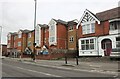
1
Bungalow at entrance to Providence Convent
Bungalow at the entrance to the Providence Convent in Oakthorpe Road, Palmers Green, N13. In the 1960s this used to be the Priest's accommodation. I do not know if that is still the case.
Image: © Christine Matthews
Taken: 14 Sep 2005
0.01 miles
2
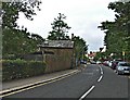
Oakthorpe Road, Palmers Green
Oakthorpe Road, Palmers Green, looking towards Green Lanes, from outside the Providence Convent. Truro House is on the left behind the trees.
Image: © Christine Matthews
Taken: 14 Sep 2005
0.02 miles
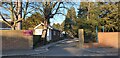
3

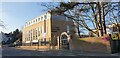
Entrance to Providence Convent, Oakthorpe Road, Palmers Green
Entrance to the Providence Convent, Oakthorpe Road, Palmers Green, N13. This used to be a private school called St Angela's, I think it then became part of the comprehensive system and the name was changed to St Anne's. The sign outside the building now just says "Providence Convent"
Image: © Christine Matthews
Taken: 14 Sep 2005
0.03 miles
4
Entrance to St Anne's Catholic High School, Palmers Green
Not much change to the entrance to the St Anne's Catholic High School (formerly St Angela's) since September 2005. Image Image
Image: © Christine Matthews
Taken: 28 Feb 2021
0.05 miles
5
St Anne's Sixth Form College, Palmers Green
This fairly new building is a Sixth Form addition to the St Anne's Catholic High School (formerly St Angela's).
Image: © Christine Matthews
Taken: 28 Feb 2021
0.05 miles
6
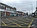
Green Lanes looking south from the traffic island at the Triangle
Green Lanes looking south from the island at the Triangle towards Central London. Woolworths on the left of the picture is about the only original shop left in this area.
Image: © Christine Matthews
Taken: 2 Jan 2006
0.05 miles
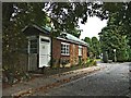
7
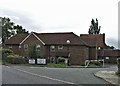
Honeysuckle House Care Home, Oakthorpe Road, Palmers Green
The Honeysuckle House Care Home is in Oakthorpe Road, Palmers Green, N13 opposite the Providence Convent.
Image: © Christine Matthews
Taken: 14 Sep 2005
0.06 miles
8
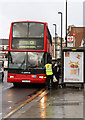
121 at Palmers Green
An Arriva bus collects passengers at Palmers Green Triangle en-route to Turnpike Lane Station. The service originated at Enfield Lock. The vehicle is a DAF DB250 with Plaxton President bodywork. It is one of the oldest still in service in London and is due to be replaced by ADL Enviro 400's in the very near future.
Image: © Martin Addison
Taken: 20 Jan 2012
0.07 miles
9
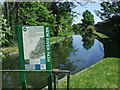
New River at Palmers Green
The New River, looking east from Green Lanes. The New River Path is a 27-mile footpath linking Hertford with Islington.
Image: © Malc McDonald
Taken: 23 May 2010
0.07 miles