IMAGES TAKEN NEAR TO
Myrtle Road, LONDON, N13 5QX
Introduction
This page details the photographs taken nearby to Myrtle Road, N13 5QX by members of the Geograph project.
The Geograph project started in 2005 with the aim of publishing, organising and preserving representative images for every square kilometre of Great Britain, Ireland and the Isle of Man.

There are currently over 7.5m images from over14,400 individuals and you can help contribute to the project by visiting https://www.geograph.org.uk
Image Map
Images are licensed for reuse under creativecommons.org/licenses/by-sa/2.0
Notes
- Clicking on the map will re-center to the selected point.
- The higher the marker number, the further away the image location is from the centre of the postcode.
Image Listing (11 Images Found)
Images are licensed for reuse under creativecommons.org/licenses/by-sa/2.0
Image
Details
Distance
1
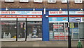
Dave's DIY, Winchmore Hill
One of the few remaining independent DIY stores.
Image: © Christine Matthews
Taken: 16 Feb 2019
0.07 miles
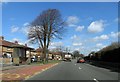
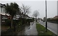
2
Ash Grove at the junction of Ensign Drive
Image: © David Howard
Taken: 7 Jan 2014
0.10 miles
3
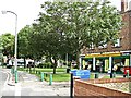
Local Shops Firs Lane
A small oasis of shops in this suburban street.
Image: © Christine Matthews
Taken: 14 Sep 2005
0.18 miles
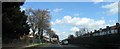
4
Ash Grove, Palmers Green, N13
Ash Grove, Palmers Green, runs between Hedge Lane and Barrowell Green.
Image: © Christine Matthews
Taken: 14 Sep 2005
0.20 miles
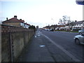
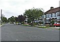
7
A10 N17
This is a good representation of the road showing the housing each side and the barrier in the middle
Image: © John Salmon
Taken: 5 Mar 2007
0.24 miles
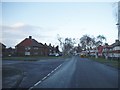
8
Hedge Lane at the junction of Firs Lane
Image: © David Howard
Taken: 7 Jan 2014
0.24 miles
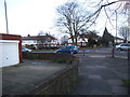
10
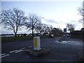
Barrowell Green at the junction of Ash Grove
Image: © David Howard
Taken: 7 Jan 2014
0.25 miles