IMAGES TAKEN NEAR TO
Firs Lane, LONDON, N13 5QF
Introduction
This page details the photographs taken nearby to Firs Lane, N13 5QF by members of the Geograph project.
The Geograph project started in 2005 with the aim of publishing, organising and preserving representative images for every square kilometre of Great Britain, Ireland and the Isle of Man.

There are currently over 7.5m images from over14,400 individuals and you can help contribute to the project by visiting https://www.geograph.org.uk
Image Map
Images are licensed for reuse under creativecommons.org/licenses/by-sa/2.0
Notes
- Clicking on the map will re-center to the selected point.
- The higher the marker number, the further away the image location is from the centre of the postcode.
Image Listing (18 Images Found)
Images are licensed for reuse under creativecommons.org/licenses/by-sa/2.0
Image
Details
Distance
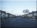
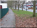
1
Ash Grove at the junction of Ensign Drive
Image: © David Howard
Taken: 7 Jan 2014
0.02 miles
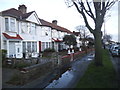
2
Ash Grove, Palmers Green, N13
Ash Grove, Palmers Green, runs between Hedge Lane and Barrowell Green.
Image: © Christine Matthews
Taken: 14 Sep 2005
0.09 miles
3
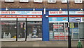
Dave's DIY, Winchmore Hill
One of the few remaining independent DIY stores.
Image: © Christine Matthews
Taken: 16 Feb 2019
0.10 miles
4
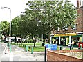
Local Shops Firs Lane
A small oasis of shops in this suburban street.
Image: © Christine Matthews
Taken: 14 Sep 2005
0.17 miles
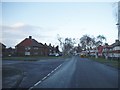
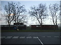
6
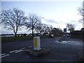
Barrowell Green at the junction of Ash Grove
Image: © David Howard
Taken: 7 Jan 2014
0.18 miles
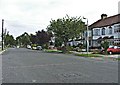
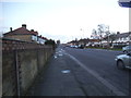
7
Barrowell Green
Barrowell Green is the road which runs from Green Lanes to Firs Lane. Clowes Sports Ground is on the left here.
Image: © Marathon
Taken: 11 Jan 2017
0.19 miles
8
Changing rooms on Barrowell Green sports ground
At the junction of Ash Grove
Image: © David Howard
Taken: 7 Jan 2014
0.19 miles