IMAGES TAKEN NEAR TO
Kelvin Avenue, LONDON, N13 4TG
Introduction
This page details the photographs taken nearby to Kelvin Avenue, N13 4TG by members of the Geograph project.
The Geograph project started in 2005 with the aim of publishing, organising and preserving representative images for every square kilometre of Great Britain, Ireland and the Isle of Man.

There are currently over 7.5m images from over14,400 individuals and you can help contribute to the project by visiting https://www.geograph.org.uk
Image Map
Images are licensed for reuse under creativecommons.org/licenses/by-sa/2.0
Notes
- Clicking on the map will re-center to the selected point.
- The higher the marker number, the further away the image location is from the centre of the postcode.
Image Listing (112 Images Found)
Images are licensed for reuse under creativecommons.org/licenses/by-sa/2.0
Image
Details
Distance
2
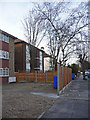
Apartment Blocks, Palmerston Road, London N13
Looking along the west side of Palmerston Road towards Bowes Road.
Image: © Christine Matthews
Taken: 11 Mar 2009
0.10 miles
3
Sidney Avenue, London N13
Sidney Avenue is a one-way street between Green Lanes and Palmerston Road.
Image: © Christine Matthews
Taken: 11 Mar 2009
0.10 miles

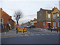
5

Green Lanes, London N13 (A105)
Looking south down Green Lanes towards Wood Green.
Image: © Christine Matthews
Taken: 11 Mar 2009
0.12 miles
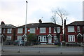
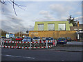
6

Houses on Bowes Road, Palmers Green
The stretch of road from here back to Bounds Green Road has been widened and modernised, although besides the new island this part has not changed as much as the rest.
Image: © David Howard
Taken: 31 Jan 2012
0.13 miles
8
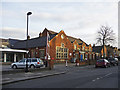
Church Hall, Trinity-at-Bowes, Palmerston Road
Adjoining the church is the church hall.
Image: © Christine Matthews
Taken: 11 Mar 2009
0.13 miles
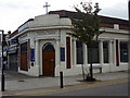
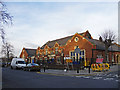
9
Trinity-at-Bowes Methodist Church, Palmerston Road
Trinity-at-Bowes Methodist Church is on the corner of Palmerston Road and Bowes Road (A406 North Circular Road).
Image: © Christine Matthews
Taken: 11 Mar 2009
0.14 miles
10
Nursery, Palmerston Road, London N13
This building, used as a nursery, is adjacent to Trinity-at-Bowes. Although the buildings at this end and on this side of Palmerston Road and Sidney Road are in the N13 postal area and the boundary between London Borough of Enfield and London Borough of Haringey are further south, the surface or the road and the west side appear to be in the N22 postcode area.
Image: © Christine Matthews
Taken: 11 Mar 2009
0.14 miles