IMAGES TAKEN NEAR TO
Moffat Road, LONDON, N13 4SA
Introduction
This page details the photographs taken nearby to Moffat Road, N13 4SA by members of the Geograph project.
The Geograph project started in 2005 with the aim of publishing, organising and preserving representative images for every square kilometre of Great Britain, Ireland and the Isle of Man.

There are currently over 7.5m images from over14,400 individuals and you can help contribute to the project by visiting https://www.geograph.org.uk
Image Map
Images are licensed for reuse under creativecommons.org/licenses/by-sa/2.0
Notes
- Clicking on the map will re-center to the selected point.
- The higher the marker number, the further away the image location is from the centre of the postcode.
Image Listing (124 Images Found)
Images are licensed for reuse under creativecommons.org/licenses/by-sa/2.0
Image
Details
Distance
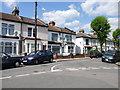
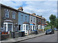
3
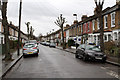
Russell Road
Looking towards the junction with Whittington Road from beside the Elim Pentecostal Church. The housing dates to circa 1880.
Image: © Martin Addison
Taken: 20 Jan 2012
0.11 miles
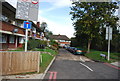
4
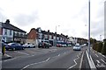
Junction of Whittingdon Road and Russell Road, near Bounds Green
Image: © Chris Whippet
Taken: 29 Apr 2009
0.12 miles
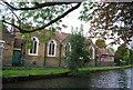
7
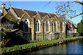
Palmers Green : Riverside Community Church
Viewed from the New River. An Elim Pentecostal church.
Image: © Jim Osley
Taken: 23 Jan 2021
0.13 miles
9
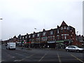
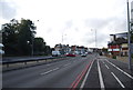
Shops on North Circular Road near Bowes Park
Image: © Chris Whippet
Taken: 7 Jan 2009
0.13 miles