IMAGES TAKEN NEAR TO
Ashridge Gardens, LONDON, N13 4LA
Introduction
This page details the photographs taken nearby to Ashridge Gardens, N13 4LA by members of the Geograph project.
The Geograph project started in 2005 with the aim of publishing, organising and preserving representative images for every square kilometre of Great Britain, Ireland and the Isle of Man.

There are currently over 7.5m images from over14,400 individuals and you can help contribute to the project by visiting https://www.geograph.org.uk
Image Map
Images are licensed for reuse under creativecommons.org/licenses/by-sa/2.0
Notes
- Clicking on the map will re-center to the selected point.
- The higher the marker number, the further away the image location is from the centre of the postcode.
Image Listing (167 Images Found)
Images are licensed for reuse under creativecommons.org/licenses/by-sa/2.0
Image
Details
Distance
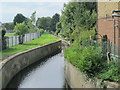

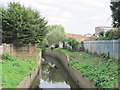
7
Pymmes Brook, Powys Lane, Palmers Green, London N13
Image: © Christine Matthews
Taken: 4 Sep 2016
0.10 miles
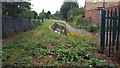
8
Powys Lane, Palmers Green, London N13
Metal Plaque Image] marks the date of the construction of the bridge over Pymmes Brook in 1907..
Image: © Christine Matthews
Taken: 4 Sep 2016
0.11 miles
9
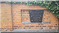
Metal Plaque on Bridge over Pymmes Brook, Powys Lane, Palmers Green, London N13
Metal Plaque on Image] marks construction of the bridge over Pymmes Brook.
Image: © Christine Matthews
Taken: 4 Sep 2016
0.11 miles