IMAGES TAKEN NEAR TO
Eaton Park Road, LONDON, N13 4EL
Introduction
This page details the photographs taken nearby to Eaton Park Road, N13 4EL by members of the Geograph project.
The Geograph project started in 2005 with the aim of publishing, organising and preserving representative images for every square kilometre of Great Britain, Ireland and the Isle of Man.

There are currently over 7.5m images from over14,400 individuals and you can help contribute to the project by visiting https://www.geograph.org.uk
Image Map
Images are licensed for reuse under creativecommons.org/licenses/by-sa/2.0
Notes
- Clicking on the map will re-center to the selected point.
- The higher the marker number, the further away the image location is from the centre of the postcode.
Image Listing (169 Images Found)
Images are licensed for reuse under creativecommons.org/licenses/by-sa/2.0
Image
Details
Distance
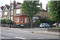
1
Lytton Avenue, Palmers Green
Complete with pre-Worboys no through road and pole
Image: © David Howard
Taken: 26 Mar 2009
0.06 miles
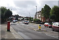
6
Green Lanes, London N13
Showing position of Postbox No. N13 9.
See Image] for postbox.
Image: © JThomas
Taken: 27 Jul 2019
0.10 miles
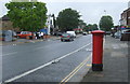
7
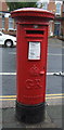
George V postbox on Green Lanes, London N13
Postbox No. N13 9.
See Image] for context.
Image: © JThomas
Taken: 27 Jul 2019
0.10 miles
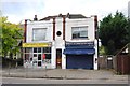
8
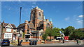
St John the Evangelist, Palmers Green London, N13
As seen on a sunny morning.
Image: © Christine Matthews
Taken: 24 Jul 2018
0.10 miles