IMAGES TAKEN NEAR TO
Lily Way, LONDON, N13 4EF
Introduction
This page details the photographs taken nearby to Lily Way, N13 4EF by members of the Geograph project.
The Geograph project started in 2005 with the aim of publishing, organising and preserving representative images for every square kilometre of Great Britain, Ireland and the Isle of Man.

There are currently over 7.5m images from over14,400 individuals and you can help contribute to the project by visiting https://www.geograph.org.uk
Image Map
Images are licensed for reuse under creativecommons.org/licenses/by-sa/2.0
Notes
- Clicking on the map will re-center to the selected point.
- The higher the marker number, the further away the image location is from the centre of the postcode.
Image Listing (129 Images Found)
Images are licensed for reuse under creativecommons.org/licenses/by-sa/2.0
Image
Details
Distance
4
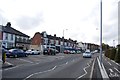
Shops on North Circular Road near Bowes Park
Image: © Chris Whippet
Taken: 7 Jan 2009
0.09 miles
5
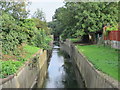
Pymme's Brook east of Powys Lane, N13
Photo taken from the Image
Image: © Mike Quinn
Taken: 9 Sep 2015
0.09 miles
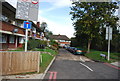
6
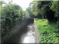
Pymme's Brook north of Westminster Drive, N13
Image: © Mike Quinn
Taken: 9 Sep 2015
0.09 miles
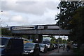
8

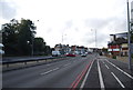
Railway bridge over the North Circular Road (A406)
Image: © Mike Quinn
Taken: 9 Sep 2015
0.11 miles

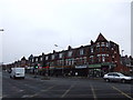
10
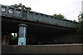
Railway bridge on the North Circular Road, Bowes Park
Image: © David Howard
Taken: 19 May 2019
0.11 miles