IMAGES TAKEN NEAR TO
Cinnamon Mews, LONDON, N13 4AQ
Introduction
This page details the photographs taken nearby to Cinnamon Mews, N13 4AQ by members of the Geograph project.
The Geograph project started in 2005 with the aim of publishing, organising and preserving representative images for every square kilometre of Great Britain, Ireland and the Isle of Man.

There are currently over 7.5m images from over14,400 individuals and you can help contribute to the project by visiting https://www.geograph.org.uk
Image Map
Images are licensed for reuse under creativecommons.org/licenses/by-sa/2.0
Notes
- Clicking on the map will re-center to the selected point.
- The higher the marker number, the further away the image location is from the centre of the postcode.
Image Listing (145 Images Found)
Images are licensed for reuse under creativecommons.org/licenses/by-sa/2.0
Image
Details
Distance
1
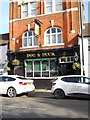
The Dog and Duck, Winchmore Hill
A popular real ale pub, the Dog and Duck is located on Hoppers Road close to the boundary between Winchmore Hill and Palmers Green. Originally constructed as two cottages, it was granted a licence to sell ale in the 18th century. The pub's name derives from the fact that it is situated close to the junction with Bourne Hill, which was formerly known as Dog and Duck Lane. The pub was rebuilt in 1900.
Sources: http://www.palmersgreenn13.com/places-2/inns-and-pubs/old-stagers/
http://www.palmersgreenn13.com/timeline/
Image: © Paul Bryan
Taken: 1 Mar 2015
0.02 miles
2
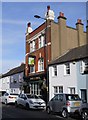
The Dog and Duck, Winchmore Hill
A popular real ale pub, the Dog and Duck is located on Hoppers Road close to the boundary between Winchmore Hill and Palmers Green. Originally constructed as two cottages, it was granted a licence to sell ale in the 18th century. The pub's name derives from the fact that it is situated close to the junction with Bourne Hill, which was formerly known as Dog and Duck Lane. The pub was rebuilt in 1900.
Sources: http://www.palmersgreenn13.com/places-2/inns-and-pubs/old-stagers/
http://www.palmersgreenn13.com/timeline/
Image: © Paul Bryan
Taken: 1 Mar 2015
0.02 miles
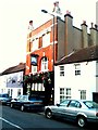
4
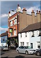
"Dog and Duck" public house, Palmers Green
Image: © Jim Osley
Taken: 31 Mar 2016
0.05 miles
5
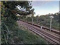
Railway line in Palmers Green
Heading northbound
Image: © David Howard
Taken: 6 Oct 2021
0.05 miles
6
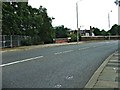
Old and New Bridges over the Railway, Bourne Hill
Here you can see the modern bridge over the railway in Bourne Hill leading to the road junction of Bourne Hill, Green Lanes and Hedge Lane, which then leads to the Cambridge Roundabout on the A10, Great Cambridge Road. To the left of this bridge you can see the old bridge, which is still used as a foot bridge.
Image: © Christine Matthews
Taken: 9 Sep 2005
0.05 miles
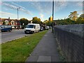
7
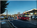
Bourne Hill, Palmers Green, London N13
Looking towards Southgate. The new zebra crossing can be seen on the left.
Image: © Christine Matthews
Taken: 16 Dec 2014
0.06 miles
8
Path over the railway line in Palmers Green
Image: © David Howard
Taken: 6 Oct 2021
0.06 miles
9

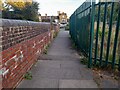
Road and footbridge over the railway line in Palmers Green
The reason for a parallel path to the main one will remain a mystery as there is plenty of room to walk over the main bridge.
Image: © David Howard
Taken: 6 Oct 2021
0.06 miles
10
Railway bridge on Hedge Lane, Palmers Green
Image: © David Howard
Taken: 6 Oct 2021
0.07 miles