IMAGES TAKEN NEAR TO
Broomfield Lane, LONDON, N13 4AF
Introduction
This page details the photographs taken nearby to Broomfield Lane, N13 4AF by members of the Geograph project.
The Geograph project started in 2005 with the aim of publishing, organising and preserving representative images for every square kilometre of Great Britain, Ireland and the Isle of Man.

There are currently over 7.5m images from over14,400 individuals and you can help contribute to the project by visiting https://www.geograph.org.uk
Image Map
Images are licensed for reuse under creativecommons.org/licenses/by-sa/2.0
Notes
- Clicking on the map will re-center to the selected point.
- The higher the marker number, the further away the image location is from the centre of the postcode.
Image Listing (297 Images Found)
Images are licensed for reuse under creativecommons.org/licenses/by-sa/2.0
Image
Details
Distance
1
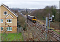
Between Bowes Park and Palmers Green
A class 313 electric multiple unit, 313046, approaches Broomfield Road bridge with a service from Moorgate to Hertford North.
Image: © Martin Addison
Taken: 20 Jan 2012
0.03 miles
2
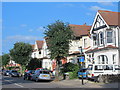
Broomfield Avenue, N13 (5)
The east side, north of Broomfield Lane.
Image: © Mike Quinn
Taken: 9 Sep 2015
0.05 miles
3
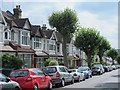
Broomfield Avenue, N13
The east side, south of Broomfield Lane.
Image: © Mike Quinn
Taken: 9 Sep 2015
0.06 miles
4
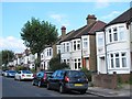
Broomfield Avenue, N13 (4)
The east side, north of Hawthorn Avenue.
Image: © Mike Quinn
Taken: 9 Sep 2015
0.09 miles
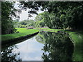
5
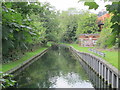
The New River west of the King's Arms Bridge (2)
See Image
Image: © Mike Quinn
Taken: 9 Sep 2015
0.10 miles
10

Palmers Green Library
Built in the late 1930's the library opened in 1940. It is currently under threat of closure and demolition along with the associated Southgate Town Hall to allow the site to be redeveloped for housing.
Image: © Martin Addison
Taken: 20 Jan 2012
0.11 miles