IMAGES TAKEN NEAR TO
St. Pauls Road, LONDON, N1 2LF
Introduction
This page details the photographs taken nearby to St. Pauls Road, N1 2LF by members of the Geograph project.
The Geograph project started in 2005 with the aim of publishing, organising and preserving representative images for every square kilometre of Great Britain, Ireland and the Isle of Man.

There are currently over 7.5m images from over14,400 individuals and you can help contribute to the project by visiting https://www.geograph.org.uk
Image Map (Loading...)


Getting Data...Please wait
Leaflet Map data © OpenStreetMap
Images are licensed for reuse under creativecommons.org/licenses/by-sa/2.0
Notes
- Clicking on the map will re-center to the selected point.
- The higher the marker number, the further away the image location is from the centre of the postcode.
Image Listing (262 Images Found)
Images are licensed for reuse under creativecommons.org/licenses/by-sa/2.0
Image
Details
Distance
1

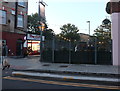
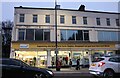
Corner Shop on Corsica Street
Corsica Street is off to the right. In front is either St Pauls Road or Holloway Road. The names change at this junction.
Image: © Des Blenkinsopp
Taken: 24 Jul 2016
0.01 miles
2
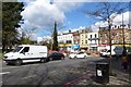
Pub garden on St Pauls Road, Highbury
Belonging to the Brewhouse and Kitchen behind it on Corsica Street
Image: © David Howard
Taken: 19 Oct 2019
0.02 miles
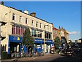
6
Marie Curie charity shop on Highbury Corner
Image: © David Howard
Taken: 18 Dec 2021
0.02 miles
7
Highbury Island
Looking across towards the north side from the east side of the roundabout.
Image: © DS Pugh
Taken: 5 Apr 2016
0.03 miles
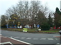
8
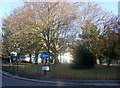
Highbury Corner trees
I had to wait a while for a vehicle-free instant!
The general impression of Highbury Corner is of a maelstrom of traffic noise, fumes and congestion but in fact this tiny island of trees and grass at the intersection of four major thoroughfares marks the scene of much greater devastation when, on June 27th 1944, a VI "doodlebug" hit the top of Upper Street, which this point then was. 26 people died and many more were injured. The roundabout was created subsequently and includes a memorial to the event.
Currently (2007) there are plans to reconstruct and redevelop this road junction and the surrounding area.
Image: © Natasha Ceridwen de Chroustchoff
Taken: 14 Nov 2007
0.03 miles
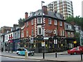
10
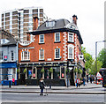
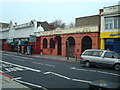
"Hen and Chickens" public house theatre, Highbury Corner
Image: © Jim Osley
Taken: 28 Apr 2017
0.03 miles