IMAGES TAKEN NEAR TO
Horsham Avenue, LONDON, N12 9BG
Introduction
This page details the photographs taken nearby to Horsham Avenue, N12 9BG by members of the Geograph project.
The Geograph project started in 2005 with the aim of publishing, organising and preserving representative images for every square kilometre of Great Britain, Ireland and the Isle of Man.

There are currently over 7.5m images from over14,400 individuals and you can help contribute to the project by visiting https://www.geograph.org.uk
Image Map
Images are licensed for reuse under creativecommons.org/licenses/by-sa/2.0
Notes
- Clicking on the map will re-center to the selected point.
- The higher the marker number, the further away the image location is from the centre of the postcode.
Image Listing (42 Images Found)
Images are licensed for reuse under creativecommons.org/licenses/by-sa/2.0
Image
Details
Distance
1
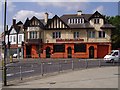
The Orange Tree, Friern Barnet Road
Image: © Roland Francois Lack
Taken: 13 Sep 2007
0.03 miles
2
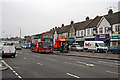
Woodhouse Road, Friern Barnet
VLW77, a Volvo with Wright body, collects passengers for Turnpike Lane Station on the 221 bus route. The shops are set back from Woodhouse Road itself on a service road called Grand Parade. It doesn't look particularly grand on a gloomy Friday though.
Image: © Martin Addison
Taken: 17 Apr 2009
0.10 miles
3
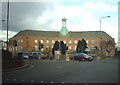
Friern Barnet Town Hall
A Grade II listed building, it is no longer the Town Hall, having been sold for conversion to housing.
Image: © Martin Addison
Taken: 17 Feb 2006
0.11 miles
4
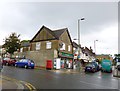
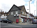
Friern Barnet Post Office
On Woodhouse Road, at the corner of Horsham Avenue.
Image: © Mike Faherty
Taken: 4 Aug 2012
0.11 miles
6
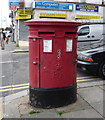
Double Elizabeth II postbox outside Friern Barnet Post Office
Postbox No. N12 24 and postbox No. N12 241.
See Image] for context.
Image: © JThomas
Taken: 23 Apr 2016
0.11 miles
7
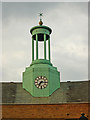
Clock and turret, former Friern Barnet Town Hall
The building has been converted to residential use.
Image: © Jim Osley
Taken: 2 Aug 2010
0.11 miles
8
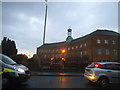
No longer Friern Barnet Town Hall
This is now a block of flats called Constable Close and Alderman Court.
Image: © David Howard
Taken: 18 Nov 2015
0.11 miles
9
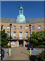
Friern Barnet: front view of the old Town Hall
An alternative view of Image
Image: © Chris Downer
Taken: 7 Sep 2012
0.11 miles
10
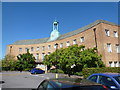
Friern Barnet: the old Town Hall
The Town Hall was built in 1941, and has now been converted to residential use.
Image: © Chris Downer
Taken: 7 Sep 2012
0.11 miles