IMAGES TAKEN NEAR TO
Poynings Way, LONDON, N12 7LP
Introduction
This page details the photographs taken nearby to Poynings Way, N12 7LP by members of the Geograph project.
The Geograph project started in 2005 with the aim of publishing, organising and preserving representative images for every square kilometre of Great Britain, Ireland and the Isle of Man.

There are currently over 7.5m images from over14,400 individuals and you can help contribute to the project by visiting https://www.geograph.org.uk
Image Map
Images are licensed for reuse under creativecommons.org/licenses/by-sa/2.0
Notes
- Clicking on the map will re-center to the selected point.
- The higher the marker number, the further away the image location is from the centre of the postcode.
Image Listing (28 Images Found)
Images are licensed for reuse under creativecommons.org/licenses/by-sa/2.0
Image
Details
Distance
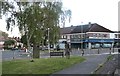
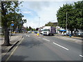
5
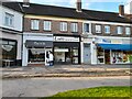
Shops on Chanctonbury Way, Woodside Park
I had just been into Nisa for a sandwich, ham and cheese on brown, very nice.
Image: © David Howard
Taken: 22 Sep 2021
0.14 miles
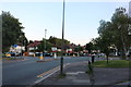

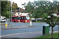
9

Sussex Ring
A roundabout with shops at the junction of, Southover Way, Argyle Road, Walmington Fold and Lullington Garth, which is the road the car is turning onto. The ring has shops only on its west side.
Image: © Martin Addison
Taken: 29 May 2007
0.15 miles