IMAGES TAKEN NEAR TO
Lorian Close, LONDON, N12 7DZ
Introduction
This page details the photographs taken nearby to Lorian Close, N12 7DZ by members of the Geograph project.
The Geograph project started in 2005 with the aim of publishing, organising and preserving representative images for every square kilometre of Great Britain, Ireland and the Isle of Man.

There are currently over 7.5m images from over14,400 individuals and you can help contribute to the project by visiting https://www.geograph.org.uk
Image Map
Images are licensed for reuse under creativecommons.org/licenses/by-sa/2.0
Notes
- Clicking on the map will re-center to the selected point.
- The higher the marker number, the further away the image location is from the centre of the postcode.
Image Listing (59 Images Found)
Images are licensed for reuse under creativecommons.org/licenses/by-sa/2.0
Image
Details
Distance
1
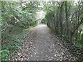
The Dollis Valley Greenwalk near Tillingham Way
The Dollis Valley Greenwalk is about ten miles long and runs from Hampstead Heath to join the Dollis Brook near the North Circular Road and then follows the brook to beyond its source at Moat Mount.
The Dollis Brook rises at Moat Mount near Arkley, firstly flowing eastwards through the open countryside of Totteridge Fields to Chipping Barnet and then through the suburbs of Barnet to Hendon. Its route can be traced by the thin strip of woodland along the riverbank and ribbon of open land on either side which provides a valuable green corridor. At Hendon the Dollis Brook meets the Mutton Brook and becomes the River Brent which then flows into the Welsh Harp Reservoir and subsequently the River Thames at Brentford.
Here the Dollis Brook is to the left and Tillingham Way is a little way ahead. This is not far from Woodside Park Underground station.
Image: © Marathon
Taken: 28 Sep 2016
0.04 miles
2
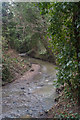
Dollis Brook, near Woodside Park
Follow the course of the Dollis Brook at this
http://www.londonslostrivers.com/dollis-brook.html
Image: © Jim Osley
Taken: 21 Feb 2018
0.07 miles
3
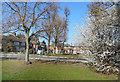
Twineham Crescent, Woodside Park
The Dollis Valley Greenwalk leaves the brook briefly and goes through here for a short detour along residential streets.
Image: © Des Blenkinsopp
Taken: 26 Feb 2019
0.09 miles
5
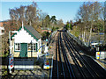
Railway north of Woodside Park
The original GNR signal box survives, at least externally.
Image: © Robin Webster
Taken: 25 Nov 2012
0.12 miles
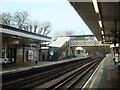
6
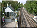
View from the footbridge at Woodside Park station
The early railways tended to avoid the high ground in the centre of the present Borough of Barnet. Finchley thus remained a largely agricultural community, providing hay for London's army of horses.
To improve communications, the Edgware, Highgate & London Railway Company opened a line in 1867 from Finsbury Park through East Finchley, and Finchley Central, and to the east of Mill Hill. On 1st April 1872 the company opened a four mile double track northwards through stations, including Torrington Park (later Woodside Park), up the eastern side of the Dollis Brook to High Barnet. The line failed to climb the steep slope up to Chipping (High) Barnet and terminated at the foot of Barnet Hill. A new villa colony near Torrington Park, Woodside caused the station to be renamed ‘Woodside Park for North Finchley’ on 1st May 1882. From 1931 the Woodside Park Garden Suburb was laid out west of the Dollis Brook and its name was added to the boards at Woodside Park station.
The new London Passenger Transport Board came into existence in 1933, and in 1935 a major railway development plan was drawn up. Under the plan, the Tube was to be extended from its then terminus at Archway to the surface at East Finchley. The lines north of East Finchley running out to High Barnet and Edgware would then be connected to the Underground at Archway, replacing the old steam routes. The Northern line was so named in 1937. Tube trains reached East Finchley in 1939 and High Barnet in 1940. Northern line Tube trains to High Barnet started on 14th April 1940 and at this time the name ‘Woodside Park and North Finchley for the Woodside Garden Suburb’ was replaced by Woodside Park. The Underground extension to Edgware from Finchley Central never got further than Mill Hill East and the rest of the project was cancelled after the War when Green Belt legislation came in.
Referring to the stations on the High Barnet branch Alan A Jackson in London’s Local Railways says: “The perceptive travellers can still discern the origins of the line; for the seeing eye ... the atmosphere of a country branch has not entirely gone.”
This view is from the footbridge at Woodside Park station and looks down the line towards Totteridge & Whetstone. The footbridge can be seen at http://www.geograph.org.uk/photo/4947260 At the end of the down platform is the unusual feature (for the Underground) of the signal box. The footbridge and signal box no doubt date from steam days. For a close up of the latter see http://www.geograph.org.uk/photo/4947251
Image: © Marathon
Taken: 28 Sep 2016
0.12 miles
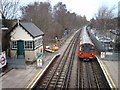
7
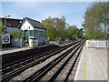
Signal box at Woodside Park Underground station
The early railways tended to avoid the high ground in the centre of the present Borough of Barnet. Finchley thus remained a largely agricultural community, providing hay for London's army of horses.
To improve communications, the Edgware, Highgate & London Railway Company opened a line in 1867 from Finsbury Park through East Finchley, and Finchley Central, and to the east of Mill Hill. On 1st April 1872 the company opened a four mile double track northwards through stations, including Torrington Park (later Woodside Park), up the eastern side of the Dollis Brook to High Barnet. The line failed to climb the steep slope up to Chipping (High) Barnet and terminated at the foot of Barnet Hill. A new villa colony near Torrington Park, Woodside caused the station to be renamed ‘Woodside Park for North Finchley’ on 1st May 1882. From 1931 the Woodside Park Garden Suburb was laid out west of the Dollis Brook and its name was added to the boards at Woodside Park station.
The new London Passenger Transport Board came into existence in 1933, and in 1935 a major railway development plan was drawn up. Under the plan, the Tube was to be extended from its then terminus at Archway to the surface at East Finchley. The lines north of East Finchley running out to High Barnet and Edgware would then be connected to the Underground at Archway, replacing the old steam routes. The Northern line was so named in 1937. Tube trains reached East Finchley in 1939 and High Barnet in 1940. Northern line Tube trains to High Barnet started on 14th April 1940 and at this time the name ‘Woodside Park and North Finchley for the Woodside Garden Suburb’ was replaced by Woodside Park. The Underground extension to Edgware from Finchley Central never got further than Mill Hill East and the rest of the project was cancelled after the War when Green Belt legislation came in.
Referring to the stations on the High Barnet branch Alan A Jackson in London’s Local Railways says: “The perceptive travellers can still discern the origins of the line; for the seeing eye ... the atmosphere of a country branch has not entirely gone.”
This view from the up platform of Woodside Park station shows the unusual feature (for the Underground) of the signal box on the end of the down platform. This no doubt dates from steam days.
Image: © Marathon
Taken: 4 May 2016
0.13 miles
8
Train and Signal Box, Woodside Park
A lot of London Underground stations out on the edges of the network retain structures from the early days, like this old signal box here at Woodside Park station.
Image: © Des Blenkinsopp
Taken: 26 Feb 2019
0.13 miles
10
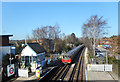
Woodside Park Station
Southbound Northern Line train arriving at Woodside Park. The building appears to be an original Great Northern Railway structure, as are the main platform buildings.
Image: © Martin Addison
Taken: 15 Feb 2006
0.13 miles