IMAGES TAKEN NEAR TO
Caledonian Road, LONDON, N1 1XP
Introduction
This page details the photographs taken nearby to Caledonian Road, N1 1XP by members of the Geograph project.
The Geograph project started in 2005 with the aim of publishing, organising and preserving representative images for every square kilometre of Great Britain, Ireland and the Isle of Man.

There are currently over 7.5m images from over14,400 individuals and you can help contribute to the project by visiting https://www.geograph.org.uk
Image Map
Images are licensed for reuse under creativecommons.org/licenses/by-sa/2.0
Notes
- Clicking on the map will re-center to the selected point.
- The higher the marker number, the further away the image location is from the centre of the postcode.
Image Listing (124 Images Found)
Images are licensed for reuse under creativecommons.org/licenses/by-sa/2.0
Image
Details
Distance
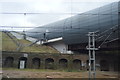
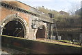
3
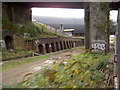
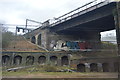
Approaching Kings Cross on the East Coast main line
The silver bridge in the background is I believe part of the channel tunnel rail link.
Image: © Steve Fareham
Taken: 27 Oct 2007
0.07 miles
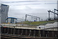
8
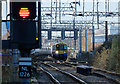
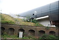
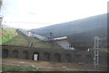
Stratford Service
London Overground class 378, 378256, approaches Caledonian Road & Barnsbury station on its way to Stratford from Richmond.
Image: © Martin Addison
Taken: 14 Dec 2017
0.09 miles