IMAGES TAKEN NEAR TO
Brooksby Street, LONDON, N1 1HA
Introduction
This page details the photographs taken nearby to Brooksby Street, N1 1HA by members of the Geograph project.
The Geograph project started in 2005 with the aim of publishing, organising and preserving representative images for every square kilometre of Great Britain, Ireland and the Isle of Man.

There are currently over 7.5m images from over14,400 individuals and you can help contribute to the project by visiting https://www.geograph.org.uk
Image Map
Images are licensed for reuse under creativecommons.org/licenses/by-sa/2.0
Notes
- Clicking on the map will re-center to the selected point.
- The higher the marker number, the further away the image location is from the centre of the postcode.
Image Listing (146 Images Found)
Images are licensed for reuse under creativecommons.org/licenses/by-sa/2.0
Image
Details
Distance
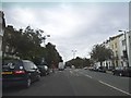
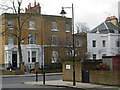
6
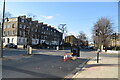
Georgian terrace on Liverpool Road, Islington
Image: © David Howard
Taken: 28 Aug 2014
0.08 miles
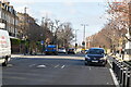
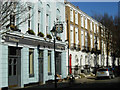
7
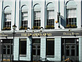
The Draper's Arms, Barnsbury
An upmarket pub to serve a well-heeled district; there is a restaurant on the first floor.
Image: © Stephen McKay
Taken: 2 Mar 2010
0.08 miles
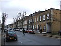
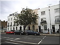
9
Bewdley Street, Barnsbury
Seen at the junction with Thornhill Road - the mid-19th century villas are typical of the area.
Image: © Stephen McKay
Taken: 28 Jan 2010
0.08 miles
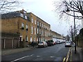
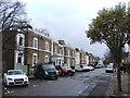
10
Barnsbury Street, Barnsbury
Looking along Barnsbury Street with the rather grand looking Draper's Arms on the left.
Image: © Stephen McKay
Taken: 2 Mar 2010
0.08 miles