IMAGES TAKEN NEAR TO
Kennard Road, LONDON, N11 3JL
Introduction
This page details the photographs taken nearby to Kennard Road, N11 3JL by members of the Geograph project.
The Geograph project started in 2005 with the aim of publishing, organising and preserving representative images for every square kilometre of Great Britain, Ireland and the Isle of Man.

There are currently over 7.5m images from over14,400 individuals and you can help contribute to the project by visiting https://www.geograph.org.uk
Image Map
Images are licensed for reuse under creativecommons.org/licenses/by-sa/2.0
Notes
- Clicking on the map will re-center to the selected point.
- The higher the marker number, the further away the image location is from the centre of the postcode.
Image Listing (60 Images Found)
Images are licensed for reuse under creativecommons.org/licenses/by-sa/2.0
Image
Details
Distance
1
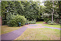
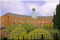
Small area of parkland behind Aldermen Court, Friern Barnet, N11
Just behind Aldermen Court (formerly Friern Barnet Town Hall), we have this small area of parkland in Friern Barnet Road.
Image: © Christine Matthews
Taken: 25 Jul 2008
0.02 miles
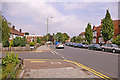
2
Looking towards Friern Barnet Road, London N11
Friern Barnet Lane as seen from outside Aldermen Court.
Image: © Christine Matthews
Taken: 25 Jul 2008
0.02 miles
3
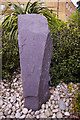
Stone at Aldermen Court, London N11
Ornamental stone in landscaped area at Aldermen Court.
Image: © Christine Matthews
Taken: 25 Jul 2008
0.03 miles
4
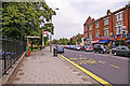
Bus stop, Friern Barnet Road, London N11
Bus stop on the north side of Friern Barnet Road. Aldermen Court is behind the railings on the left of the image.
Image: © Christine Matthews
Taken: 25 Jul 2008
0.03 miles
5
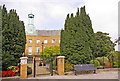
Aldermen Court, London N11
Aldermen Court is an apartment block in the converted former Friern Barnet Town Hall building, on the corner of Friern Barnet Lane and Friern Barnet Road.
Image: © Christine Matthews
Taken: 25 Jul 2008
0.03 miles
6
Aldermen Court, London N11
Aldermen Court is an apartment block in the former Friern Barnet Town Hall building. The building has been converted and landscaped.
Image: © Christine Matthews
Taken: 25 Jul 2008
0.03 miles
8
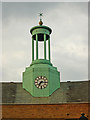
Clock and turret, former Friern Barnet Town Hall
The building has been converted to residential use.
Image: © Jim Osley
Taken: 2 Aug 2010
0.05 miles
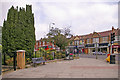
10
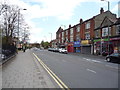
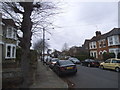
Friern Barnet Road, London N11
Looking east down Friern Barnet Road near junction with Kennard Road.
Image: © Christine Matthews
Taken: 25 Jul 2008
0.05 miles