IMAGES TAKEN NEAR TO
Hartland Road, LONDON, N11 3JJ
Introduction
This page details the photographs taken nearby to Hartland Road, N11 3JJ by members of the Geograph project.
The Geograph project started in 2005 with the aim of publishing, organising and preserving representative images for every square kilometre of Great Britain, Ireland and the Isle of Man.

There are currently over 7.5m images from over14,400 individuals and you can help contribute to the project by visiting https://www.geograph.org.uk
Image Map (Loading...)


Getting Data...Please wait
Leaflet Map data © OpenStreetMap
Images are licensed for reuse under creativecommons.org/licenses/by-sa/2.0
Notes
- Clicking on the map will re-center to the selected point.
- The higher the marker number, the further away the image location is from the centre of the postcode.
Image Listing (61 Images Found)
Images are licensed for reuse under creativecommons.org/licenses/by-sa/2.0
Image
Details
Distance
2
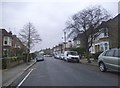
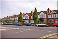
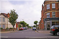
Friern Barnet Road, London N11
Looking east down Friern Barnet Road near junction with Kennard Road.
Image: © Christine Matthews
Taken: 25 Jul 2008
0.03 miles
3
Goldsmith Road at the corner of Hartland Road
Image: © David Howard
Taken: 18 Nov 2015
0.03 miles
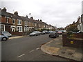
5
St John's Terrace, Friern Barnet Road, London N11
St John's Terrace as seen from Kennard Road.
Image: © Christine Matthews
Taken: 25 Jul 2008
0.03 miles
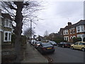
6
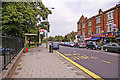
Bus stop, Friern Barnet Road, London N11
Bus stop on the north side of Friern Barnet Road. Aldermen Court is behind the railings on the left of the image.
Image: © Christine Matthews
Taken: 25 Jul 2008
0.05 miles
7
Looking towards Friern Barnet Road, London N11
Friern Barnet Lane as seen from outside Aldermen Court.
Image: © Christine Matthews
Taken: 25 Jul 2008
0.06 miles
8
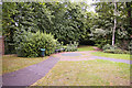
Small area of parkland behind Aldermen Court, Friern Barnet, N11
Just behind Aldermen Court (formerly Friern Barnet Town Hall), we have this small area of parkland in Friern Barnet Road.
Image: © Christine Matthews
Taken: 25 Jul 2008
0.06 miles
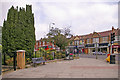
9
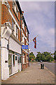
Pavement outside Royal British Legion, Friern Barnet Road, London N11
Past the white shopfront we have the Friern Barnet Royal British Legion, flying the Union Flag. This is almost opposite St John the Evangelist.
Image: © Christine Matthews
Taken: 25 Jul 2008
0.06 miles
10
Hollyfield Avenue, London N11
Hollyfield Avenue as seen from Friern Barnet Road.
Image: © Christine Matthews
Taken: 25 Jul 2008
0.07 miles