IMAGES TAKEN NEAR TO
The Crescent, LONDON, N11 3HH
Introduction
This page details the photographs taken nearby to The Crescent, N11 3HH by members of the Geograph project.
The Geograph project started in 2005 with the aim of publishing, organising and preserving representative images for every square kilometre of Great Britain, Ireland and the Isle of Man.

There are currently over 7.5m images from over14,400 individuals and you can help contribute to the project by visiting https://www.geograph.org.uk
Image Map
Images are licensed for reuse under creativecommons.org/licenses/by-sa/2.0
Notes
- Clicking on the map will re-center to the selected point.
- The higher the marker number, the further away the image location is from the centre of the postcode.
Image Listing (26 Images Found)
Images are licensed for reuse under creativecommons.org/licenses/by-sa/2.0
Image
Details
Distance
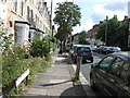
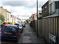
3
Path between Stanford Road and Glenthorne Road
Image: © David Howard
Taken: 18 Nov 2015
0.13 miles
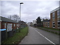
5
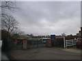
The entrance to St Johns Primary School, Friern Barnet
Image: © David Howard
Taken: 18 Nov 2015
0.14 miles
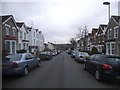
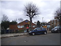
6

Glenthorne Rd Friern Barnet
View along Glenthorne from close to the junction with Barnet Rd
Image: © Nigel Mykura
Taken: 22 Dec 2008
0.14 miles
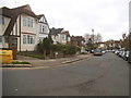
7
Scout and guide hut on Stanford Road, Friern Barnet
Image: © David Howard
Taken: 18 Nov 2015
0.14 miles
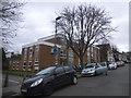
10
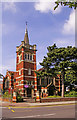
Christ Church, Friern Barnet Road, London N11
Christ Church Baptist/United Reformed Church as seen from the other side of Friern Barnet Road.
Image: © Christine Matthews
Taken: 25 Jul 2008
0.20 miles