IMAGES TAKEN NEAR TO
Beaconsfield Close, LONDON, N11 3GY
Introduction
This page details the photographs taken nearby to Beaconsfield Close, N11 3GY by members of the Geograph project.
The Geograph project started in 2005 with the aim of publishing, organising and preserving representative images for every square kilometre of Great Britain, Ireland and the Isle of Man.

There are currently over 7.5m images from over14,400 individuals and you can help contribute to the project by visiting https://www.geograph.org.uk
Image Map
Images are licensed for reuse under creativecommons.org/licenses/by-sa/2.0
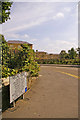
Notes
- Clicking on the map will re-center to the selected point.
- The higher the marker number, the further away the image location is from the centre of the postcode.
Image Listing (87 Images Found)
Images are licensed for reuse under creativecommons.org/licenses/by-sa/2.0
Image
Details
Distance
1
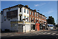
Shops on Friern Barnet Road
Shops with accommodation above located between Beaconsfield Road and the Kings Cross to Scotland main line.
Image: © Martin Addison
Taken: 25 Sep 2009
0.02 miles
2
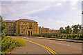
Housing in Regal Drive, Friern Barnet, London N11
Looking down Regal Drive at the attractive housing development.
Image: © Christine Matthews
Taken: 25 Jul 2008
0.02 miles
3

George V postbox on Friern Barnet Road
Image: © JThomas
Taken: 23 Apr 2016
0.02 miles
4

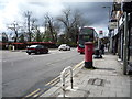
Friern Barnet Road
Looking east showing position of Postbox No. N11 22.
Image: © JThomas
Taken: 23 Apr 2016
0.02 miles
5
Friern Barnet Road
Looking west showing position of Postbox No. N11 22.
See Image] for postbox.
Image: © JThomas
Taken: 23 Apr 2016
0.02 miles
6
Regal Drive, Friern Barnet, London N11
Looking down Regal Drive, part of a fairly new development/renovation of existing buildings on the site of the old Colney Hatch Hospital.
Image: © Christine Matthews
Taken: 25 Jul 2008
0.03 miles
7
Road sign, Regal Drive, Friern Barnet, London N11
Road sign with names of the connecting roads on this estate of homes renovated/constructed on the site of the Colney Hatch Hospital.
Image: © Christine Matthews
Taken: 25 Jul 2008
0.03 miles
8
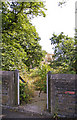
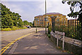
Gateway to footpath to housing, Friern Barnet, London N11
Gateway from the access route to New Southgate Station leading to the housing on the site of the old Colney Hatch Hospital.
Image: © Christine Matthews
Taken: 25 Jul 2008
0.04 miles
9
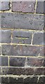
Ordnance Survey Cut Mark
This OS cut mark can be found on the south parapet of the railway bridge. It marks a point 62.390m above mean sea level.
Image: © Adrian Dust
Taken: 2 Aug 2016
0.05 miles
10
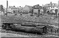
Locomotive humbled after serious derailment at New Southgate
View eastward, across the East Coast Main Line just north of New Southgate Station. [See my 'Triumph and Beyond: the East Coast Main Line, 1939 - 1959, Part 1', Challenger, 1998]. Owing to poor maintenance of the track after the War, the overnight 19.50 Edinburgh - King's Cross derailed at 70 mph north of New Southgate station. The engine became detached from the train and slid along 100 yards. The fireman was killed and the driver injured, but the passengers were relatively unscathed. The locomotive is A2/1 Pacific 60508 'Duke of Rothesay' and the driver was the celebrated Bill Hoole. (See also Adrian Gray 'East Coast Main Line Disasters', Pendragon Publication 2013).
Image: © Ben Brooksbank
Taken: 17 Jul 1948
0.06 miles