IMAGES TAKEN NEAR TO
Royal Drive, LONDON, N11 3FR
Introduction
This page details the photographs taken nearby to Royal Drive, N11 3FR by members of the Geograph project.
The Geograph project started in 2005 with the aim of publishing, organising and preserving representative images for every square kilometre of Great Britain, Ireland and the Isle of Man.

There are currently over 7.5m images from over14,400 individuals and you can help contribute to the project by visiting https://www.geograph.org.uk
Image Map
Images are licensed for reuse under creativecommons.org/licenses/by-sa/2.0
Notes
- Clicking on the map will re-center to the selected point.
- The higher the marker number, the further away the image location is from the centre of the postcode.
Image Listing (36 Images Found)
Images are licensed for reuse under creativecommons.org/licenses/by-sa/2.0
Image
Details
Distance
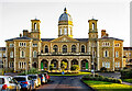
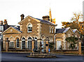
1

Friern Barnet : Princess Park Manor
Entrance block to the former Colney Hatch Asylum. More information at Image Architect: Samuel W. Daukes. Grade II listed : description at this https://historicengland.org.uk/listing/the-list/list-entry/1078848?section=official-listing.
Image: © Jim Osley
Taken: 16 Jan 2022
0.13 miles
2
Friern Barnet : Princess Park Manor
Entrance block to the former Colney Hatch Asylum. More information at Image Architect: Samuel W. Daukes. Grade II listed : description at this https://historicengland.org.uk/listing/the-list/list-entry/1078848?section=official-listing.
Image: © Jim Osley
Taken: 16 Jan 2022
0.13 miles
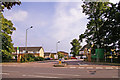
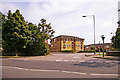
3
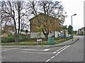
Corner of Garsdale Close, London N11
Corner of Garsdale Close, N11. This is part of a new housing estate.
Image: © Christine Matthews
Taken: 5 Nov 2005
0.15 miles
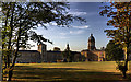
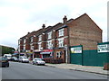
4
Housing, Friern Barnet Road, London N11
Some of the renovated buildings from the old Colney Hatch Hospital. This is a very attractive, landscaped complex.
Image: © Christine Matthews
Taken: 25 Jul 2008
0.17 miles
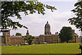
5
Princes Park Manor
Originally Colney Hatch Asylum. Building started in 1849 to a design by S W Daukes. The foundation stone was laid by Prince Albert. The asylum opened in 1851. It was built to hold 1000 patients and had 6 miles of corridors - it was the largest in Europe. The site was extended over time to hold 2000 patients and the name Colney Hatch became synonymous with madness, such that the hospital name was changed on several occasions, finally becoming Friern Hospital in 1959. It closed in 1993 and was converted to housing. A fuller history is available from http://www.barnet.gov.uk/index/leisure-culture/libraries/archives/archives-histories/archives-finchleyhistories/archives-finchley-colneyhatchasylum.htm
Image: © Martin Addison
Taken: 25 Sep 2009
0.19 miles
6
Friern Barnet : lodge, Princess Park Manor
Image: © Jim Osley
Taken: 16 Jan 2022
0.19 miles
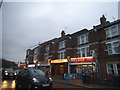
9
Side turning opposite Library, Friern Barnet Road, London N11
I think this could be a crescent connected to the side turning in my other image Image
Image: © Christine Matthews
Taken: 25 Jul 2008
0.20 miles
10
Side turning opposite open land, Friern Barnet Road, London N11
Seems to be a new development, name of road isn't on map at the moment.
Image: © Christine Matthews
Taken: 25 Jul 2008
0.20 miles