IMAGES TAKEN NEAR TO
Friern Barnet Road, LONDON, N11 3EQ
Introduction
This page details the photographs taken nearby to Friern Barnet Road, N11 3EQ by members of the Geograph project.
The Geograph project started in 2005 with the aim of publishing, organising and preserving representative images for every square kilometre of Great Britain, Ireland and the Isle of Man.

There are currently over 7.5m images from over14,400 individuals and you can help contribute to the project by visiting https://www.geograph.org.uk
Image Map
Images are licensed for reuse under creativecommons.org/licenses/by-sa/2.0
Notes
- Clicking on the map will re-center to the selected point.
- The higher the marker number, the further away the image location is from the centre of the postcode.
Image Listing (62 Images Found)
Images are licensed for reuse under creativecommons.org/licenses/by-sa/2.0
Image
Details
Distance
1
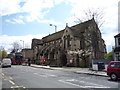
St John the Evangelist Church
On Friern Barnet Road.
Image: © JThomas
Taken: 23 Apr 2016
0.03 miles
2
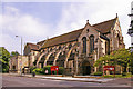
St John the Evangelist, Friern Barnet Road, London N11
Image: © Christine Matthews
Taken: 25 Jul 2008
0.03 miles
3
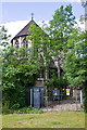
The Power of St. John
A small electricity sub-station on the corner of Shapwick Close is dwarfed by the church of St. John the Evangelist. Please see Image by Christine Matthews for a full view of the church.
Image: © Martin Addison
Taken: 28 May 2009
0.04 miles
4
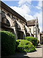
St. John The Evangelist
Located on Friern Barnet Road. Please see Image by Christine Matthews for a full view.
Image: © Martin Addison
Taken: 28 May 2009
0.04 miles
6
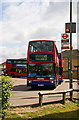
Terminus For The 43
On Friern Barnet Road, between Martock Gardens and Shapwick Close. VP495, a Volvo with Plaxton body, prepares to depart for London Bridge Station. A long route, often affected by traffic congestion, there were 30 vehicles allocated to this service on weekdays in 2005 - info from London Bus Routes at http://www.busesatwork.co.uk/
Image: © Martin Addison
Taken: 28 May 2009
0.06 miles
7
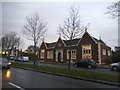
Public Library
Public library Friern Barnet.
Image: © Keith Evans
Taken: 11 Sep 2013
0.06 miles
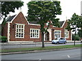
8
Friern Barnet British Legion
Located on Friern Barnet Road at the junction with Ramsden Road.
Image: © Martin Addison
Taken: 28 May 2009
0.07 miles
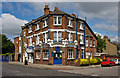
9
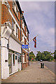
Pavement outside Royal British Legion, Friern Barnet Road, London N11
Past the white shopfront we have the Friern Barnet Royal British Legion, flying the Union Flag. This is almost opposite St John the Evangelist.
Image: © Christine Matthews
Taken: 25 Jul 2008
0.07 miles
10
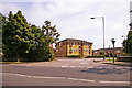
Side turning opposite open land, Friern Barnet Road, London N11
Seems to be a new development, name of road isn't on map at the moment.
Image: © Christine Matthews
Taken: 25 Jul 2008
0.07 miles