IMAGES TAKEN NEAR TO
Hollyfield Avenue, LONDON, N11 3BY
Introduction
This page details the photographs taken nearby to Hollyfield Avenue, N11 3BY by members of the Geograph project.
The Geograph project started in 2005 with the aim of publishing, organising and preserving representative images for every square kilometre of Great Britain, Ireland and the Isle of Man.

There are currently over 7.5m images from over14,400 individuals and you can help contribute to the project by visiting https://www.geograph.org.uk
Image Map
Images are licensed for reuse under creativecommons.org/licenses/by-sa/2.0
Notes
- Clicking on the map will re-center to the selected point.
- The higher the marker number, the further away the image location is from the centre of the postcode.
Image Listing (60 Images Found)
Images are licensed for reuse under creativecommons.org/licenses/by-sa/2.0
Image
Details
Distance
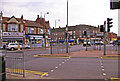
1
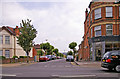
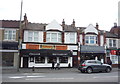
Hollyfield Avenue, London N11
Hollyfield Avenue as seen from Friern Barnet Road.
Image: © Christine Matthews
Taken: 25 Jul 2008
0.05 miles
4
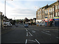
Junction of Friern Barnet Lane and Colney Hatch Lane, London N11
Taken from outside Aldermen Court, looking across the road junction with Colney Hatch Lane.
Image: © Christine Matthews
Taken: 25 Jul 2008
0.07 miles
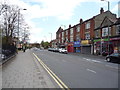
6
Colney Hatch Lane
From the Junction with Friern Barnet Road, looking towards Alexandra Palace, which is visible on the horizon. The art deco style building with a flag pole, at the end of the parade of shops, was the youth employment and careers advice centre - the words just legible in the weathering of the white paint.
Image: © Martin Addison
Taken: 11 Aug 2006
0.07 miles
7
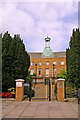
Entrance to Aldermen Court, London N11
Gated entrance to Aldermen Court (formerly Friern Barnet Town Hall).
Image: © Christine Matthews
Taken: 25 Jul 2008
0.07 miles
8
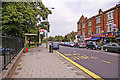
Bus stop, Friern Barnet Road, London N11
Bus stop on the north side of Friern Barnet Road. Aldermen Court is behind the railings on the left of the image.
Image: © Christine Matthews
Taken: 25 Jul 2008
0.08 miles
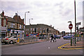
9
Pedestrian Crossing area at traffic Lights, Friern Barnet, London N11
Crossing for pedestrians outside Aldermen Court.
Image: © Christine Matthews
Taken: 25 Jul 2008
0.08 miles
10
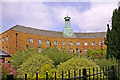
Aldermen Court, London N11
Aldermen Court is an apartment block in the converted former Friern Barnet Town Hall building, on the corner of Friern Barnet Lane and Friern Barnet Road.
Image: © Christine Matthews
Taken: 25 Jul 2008
0.08 miles