IMAGES TAKEN NEAR TO
Bosworth Road, LONDON, N11 2SY
Introduction
This page details the photographs taken nearby to Bosworth Road, N11 2SY by members of the Geograph project.
The Geograph project started in 2005 with the aim of publishing, organising and preserving representative images for every square kilometre of Great Britain, Ireland and the Isle of Man.

There are currently over 7.5m images from over14,400 individuals and you can help contribute to the project by visiting https://www.geograph.org.uk
Image Map
Images are licensed for reuse under creativecommons.org/licenses/by-sa/2.0
Notes
- Clicking on the map will re-center to the selected point.
- The higher the marker number, the further away the image location is from the centre of the postcode.
Image Listing (69 Images Found)
Images are licensed for reuse under creativecommons.org/licenses/by-sa/2.0
Image
Details
Distance
2
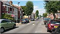
Natal Road
Typical side street in this area: traffic calming measures, shade trees and lots of parked cars.
Image: © David Martin
Taken: 9 Sep 2014
0.09 miles
3
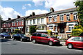
Houses on Brownlow RD
This is a residential street with mainly terraced houses from the Victorian era although several of the houses are substantial double fronted terraced houses.
Image: © Nigel Mykura
Taken: 7 Jun 2015
0.09 miles
4
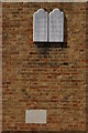
Tablets and foundation stone on United Synagogue, Brownlow Road, N11
To see this in its context, go to Image
Image: © Christopher Hilton
Taken: 17 Aug 2017
0.11 miles
5
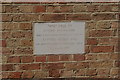
Foundation stone on United Synagogue, Brownlow Road, N11
To see this in its context, go to Image
Image: © Christopher Hilton
Taken: 17 Aug 2017
0.11 miles
6
United Synagogue, Brownlow Road, N11
The architecture, with its combination of brick with a heavy concrete lip around the window, cries out 1950s; something borne out by the foundation stone (see Image).
Image: © Christopher Hilton
Taken: 17 Aug 2017
0.11 miles
7
Highworth Road
To the right is Bowes Primary School which was rated as "Outstanding" by OFSTED when inspected in 2013.
Image: © Andrew Tatlow
Taken: 23 Aug 2015
0.11 miles
8
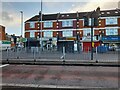
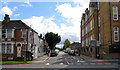
The North Circular, Bounds Green
A few years ago the right turn to Brownlow Road was turned into buses only. I have no idea where other vehicles are supposed to go as there are no blocks available to go around.
Image: © David Howard
Taken: 31 Oct 2021
0.11 miles
9
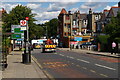
Approaching the junction of Brownlow Road and Bowes Road
Beyond the modern road direction sign seen here is a pre-Worboys equivalent (see Image).
Image: © Christopher Hilton
Taken: 17 Aug 2017
0.12 miles