IMAGES TAKEN NEAR TO
Eleanor Road, LONDON, N11 2QS
Introduction
This page details the photographs taken nearby to Eleanor Road, N11 2QS by members of the Geograph project.
The Geograph project started in 2005 with the aim of publishing, organising and preserving representative images for every square kilometre of Great Britain, Ireland and the Isle of Man.

There are currently over 7.5m images from over14,400 individuals and you can help contribute to the project by visiting https://www.geograph.org.uk
Image Map
Images are licensed for reuse under creativecommons.org/licenses/by-sa/2.0
Notes
- Clicking on the map will re-center to the selected point.
- The higher the marker number, the further away the image location is from the centre of the postcode.
Image Listing (215 Images Found)
Images are licensed for reuse under creativecommons.org/licenses/by-sa/2.0
Image
Details
Distance
1
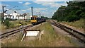
Northbound train departing Bowes Park station
Image: © David Martin
Taken: 25 Jun 2015
0.05 miles
2
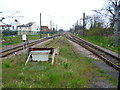
View from the end of the platform at Bowes Park station
The Alexandra Palace-Hertford-Stevenage loop was built mainly as a by-pass for the approaches to King's Cross on the main line from Hatfield and was built to main line standards for much of its length. However, it has never carried regular long-distance passenger services and has always primarily been a suburban branch, apart from when there is engineering work or other disruption on the East Coast Main Line through Hatfield.
The line was opened as far as Enfield, which was then the terminus, on 1st April 1871. The line was extended to Cuffley from 4th April 1910 and on to Stevenage for freight on 4th March 1918, but passenger trains only started beyond Cuffley on 2nd June 1924.
A map of 1880 shows Wood Green growing between Green Lanes and the railway to Enfield and so the Great Northern Railway opened Bowes Park station on 1st November 1880. The centre track was controlled from a small signal box and provided for rush-hour reversals. By the end of the 1890s the station was very busy with new streets extending almost as far as Palmers Green.
Bowes Park is the only station on the entire Hertford Loop with an island platform. This view looks from the end of the platform along the rather overgrown centre track. The next station in this direction is Palmers Green.
Image: © Marathon
Taken: 8 Apr 2015
0.05 miles
3
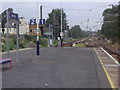
Bowes Park station platform looking north
Image: © David Howard
Taken: 27 Aug 2008
0.05 miles
4
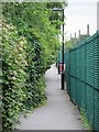
Footpath by the eastern ends of Herbert Road and Richmond Road, N11
Image: © Mike Quinn
Taken: 20 Aug 2015
0.06 miles
5

Crab Apple Blossom, London N11
Although a crab apple, the apples are not all that sour and have pink flesh.
Image: © Christine Matthews
Taken: 2 May 2021
0.06 miles
6
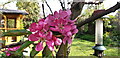
Crab Apple Blossom, London N11
Although a crab apple, the apples are not all that sour and have pink flesh.
Image: © Christine Matthews
Taken: 2 May 2021
0.06 miles
7
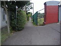
Footpath to Richmond Road and Bowes Park station
Image: © David Howard
Taken: 27 Aug 2008
0.06 miles
8
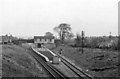
Bowes Park Station
View NE, towards Hertford; ex-GNR Wood Green - Hertford North - Stevenage loop line, subsequently electrified (southward from 8/11/76, northward from 6/2/78).
Image: © Ben Brooksbank
Taken: 1 Apr 1961
0.07 miles
9
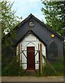
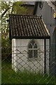
'Tin tabernacle', Bowes Park (1)
Also known as Shaftesbury Hall. A rare example of its kind, a 19th century prefabricated church clad in corrugated iron. Currently not used, with an uncertain future, as it does not have listed building protection. For more images of these types of buildings visit this http://www.tintabernacles.co.uk/site_page.php?page=4
Image: © Jim Osley
Taken: 18 Apr 2011
0.08 miles