IMAGES TAKEN NEAR TO
Palmers Road, LONDON, N11 1SL
Introduction
This page details the photographs taken nearby to Palmers Road, N11 1SL by members of the Geograph project.
The Geograph project started in 2005 with the aim of publishing, organising and preserving representative images for every square kilometre of Great Britain, Ireland and the Isle of Man.

There are currently over 7.5m images from over14,400 individuals and you can help contribute to the project by visiting https://www.geograph.org.uk
Image Map
Images are licensed for reuse under creativecommons.org/licenses/by-sa/2.0
Notes
- Clicking on the map will re-center to the selected point.
- The higher the marker number, the further away the image location is from the centre of the postcode.
Image Listing (147 Images Found)
Images are licensed for reuse under creativecommons.org/licenses/by-sa/2.0
Image
Details
Distance
1
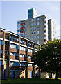
Ladderswood Estate
Highrise blocks loom over midrise housing between Palmers Road and Highview Gardens
Image: © Martin Addison
Taken: 25 Sep 2009
0.03 miles
2
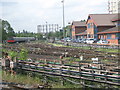
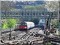
Tube sidings south of Arnos Grove station
Image: © Mike Quinn
Taken: 12 May 2009
0.05 miles
3

Ladderswood Estate
Mason House, one of the midrise blocks located along Upper Park Road. The road in the foreground is Ladderswood Way. The two highrise blocks beyond are located on Highview Gardens. Highrise blocks on the estate are earmarked for demolition under Enfield Borough's housing renewal plan. Whether the two in the photo are included, I am not sure.
Image: © Martin Addison
Taken: 25 Sep 2009
0.08 miles
4
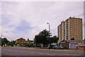
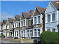
Station Road, London N11 (A109)
Looking across Station Road towards Lower Park Road.
Image: © Christine Matthews
Taken: 16 Aug 2008
0.09 miles
5
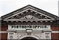
Pediment, Royal Mail delivery office, New Southgate
For a full view of this building see Image
Image: © Jim Osley
Taken: 20 Mar 2014
0.09 miles
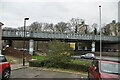
6
Lines south of Arnos Grove tube station
See Image
Image: © Mike Quinn
Taken: 5 Apr 2017
0.09 miles
7
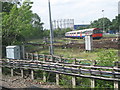
Tube sidings south of Arnos Grove station (2)
Image: © Mike Quinn
Taken: 12 May 2009
0.10 miles
10

Ladderswood Estate
Curtis House, a highrise block of flats located beside Ladderswood Way. This block, along with the other highrise blocks on the estate, is earmarked for demolition under Enfield Borough's housing renewal plan. The wall the right belongs to Betspath House.
Image: © Martin Addison
Taken: 25 Sep 2009
0.11 miles