IMAGES TAKEN NEAR TO
High Road, LONDON, N11 1PP
Introduction
This page details the photographs taken nearby to High Road, N11 1PP by members of the Geograph project.
The Geograph project started in 2005 with the aim of publishing, organising and preserving representative images for every square kilometre of Great Britain, Ireland and the Isle of Man.

There are currently over 7.5m images from over14,400 individuals and you can help contribute to the project by visiting https://www.geograph.org.uk
Image Map
Images are licensed for reuse under creativecommons.org/licenses/by-sa/2.0
Notes
- Clicking on the map will re-center to the selected point.
- The higher the marker number, the further away the image location is from the centre of the postcode.
Image Listing (110 Images Found)
Images are licensed for reuse under creativecommons.org/licenses/by-sa/2.0
Image
Details
Distance
1

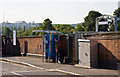
Footpath to the High Road
Pedestrian route between Whitmore Close and High Road. The Cars seen through the arch are parked on Springfield Road. High Road is at right angles to the path.
Image: © Martin Addison
Taken: 25 Sep 2009
0.01 miles
2

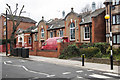
High Road Shops
Shops built into the housing on the new estate located between High Road and Station Road. A customer can be seen entering New Southgate Foos and Wine. The street is the High Road and the road on the left is Whitmore Close. Nice looking brick and slate appearance, shame about the concrete flower beds.
Image: © Martin Addison
Taken: 25 Sep 2009
0.02 miles
3

Whitmore Close
Modern housing on this estate built around the High Road and located between Station Road and the Ladderswood Estate.
Image: © Martin Addison
Taken: 25 Sep 2009
0.03 miles
4
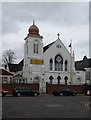
From chapel to temple, New Southgate
Example of how religious buildings are altered to reflect their use. The Sikh temple in the image was built as a Wesleyan chapel, with now with the addition of an onion dome.
Image: © Jim Osley
Taken: 20 Mar 2014
0.03 miles
6
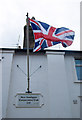
Royal Mail delivery office, New Southgate
Late Edwardian sorting office, built c.1910.
Image: © Jim Osley
Taken: 20 Mar 2014
0.07 miles
7

Cedar Court
Located on Upper Park Road, this appears to be a 1950's housing development. The apartments are located around three sides of the central quadrangle.
Image: © Martin Addison
Taken: 25 Sep 2009
0.10 miles
8
New Southgate Station
The station entrance on Station Road. A ticket machine is provided - there are others on the station. Visible above the trees is Alexandra Palace.
Image: © Martin Addison
Taken: 25 Sep 2009
0.11 miles

10
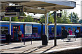
New Southgate Station
Late morning commuters board a Kings Cross bound train.
Image: © Martin Addison
Taken: 25 Sep 2009
0.11 miles