IMAGES TAKEN NEAR TO
Carlisle Place, LONDON, N11 1JW
Introduction
This page details the photographs taken nearby to Carlisle Place, N11 1JW by members of the Geograph project.
The Geograph project started in 2005 with the aim of publishing, organising and preserving representative images for every square kilometre of Great Britain, Ireland and the Isle of Man.

There are currently over 7.5m images from over14,400 individuals and you can help contribute to the project by visiting https://www.geograph.org.uk
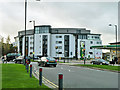
Image Map
Images are licensed for reuse under creativecommons.org/licenses/by-sa/2.0
Notes
- Clicking on the map will re-center to the selected point.
- The higher the marker number, the further away the image location is from the centre of the postcode.
Image Listing (95 Images Found)
Images are licensed for reuse under creativecommons.org/licenses/by-sa/2.0
Image
Details
Distance
1
Arc Court
A building curving through about 90 degrees front and back.
Image: © Robin Webster
Taken: 25 Nov 2012
0.05 miles
2
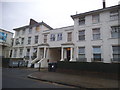
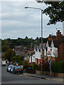
Victorian houses on Friern Barnet Road
No doubt these are now divided into the smallest possible units.
Image: © David Howard
Taken: 18 Nov 2015
0.06 miles
3
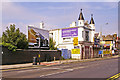
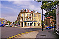
The Turrets, Friern Barnet Road, London N11
Originally the Railway Tavern, the Turrets was built in 1887. In the late 1960s/1970s it was a popular social venue with a function room where discos and folk singing evenings were held. Latterly it became Kites Nightclub. It has been boarded up for years. Apparently it is a listed building, so watch this space.
Image: © Christine Matthews
Taken: 25 Jul 2008
0.07 miles
4
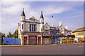
The Turrets, Friern Barnet Road, London N11
Originally the Railway Hotel, which was opened in 1856, it was re-built in 1887. I am not sure when it was re-named "The Turrets", but it was still the Railway Hotel in the early 1900s. In the late 1960s/early 1970s it was a popular social venue with a function room where discos and folk singing evenings were held. Latterly it became Kites Nightclub. It has been boarded up for several years. Apparently it is a listed building, so presumably the facade would need to be kept if it were redeveloped.
See link to how the pub looked before the turreted extensions were added, probably in the late 1880s.
https://www.flickr.com/photos/59035330@N05/8059900015/
Image: © Christine Matthews
Taken: 25 Jul 2008
0.07 miles
5
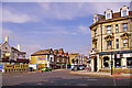
Junction of Station Road and Friern Barnet Road, London N11
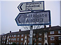
Looking east up Friern Barnet Road (A1003). Station Road on the right leads to the North Circular Road (A406).
Image: © Christine Matthews
Taken: 25 Jul 2008
0.08 miles
6
The Bank public house, corner Station Road, London N11
The Bank public house was originally a branch of the National Westminster Bank. After conversion to a public house it was originally called the "Bankers Draft". It is now called just "The Bank".
Image: © Christine Matthews
Taken: 25 Jul 2008
0.08 miles
8
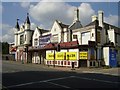
Brunswick Park Road, New Southgate
Leading down the hill from Betstyle Circus towards East Barnet. The bus stop is served by route 382 between Southgate Station and Millbrook Park.
Image: © Stephen McKay
Taken: 3 Oct 2017
0.09 miles
10
The Turrets
Before this was the Turrets it was the Railway Tavern, and more recently was Kites nightclub. Apparently a listed building.
Image: © Roland Francois Lack
Taken: 13 Sep 2007
0.10 miles