IMAGES TAKEN NEAR TO
Waterfall Road, LONDON, N11 1JE
Introduction
This page details the photographs taken nearby to Waterfall Road, N11 1JE by members of the Geograph project.
The Geograph project started in 2005 with the aim of publishing, organising and preserving representative images for every square kilometre of Great Britain, Ireland and the Isle of Man.

There are currently over 7.5m images from over14,400 individuals and you can help contribute to the project by visiting https://www.geograph.org.uk
Image Map
Images are licensed for reuse under creativecommons.org/licenses/by-sa/2.0
Notes
- Clicking on the map will re-center to the selected point.
- The higher the marker number, the further away the image location is from the centre of the postcode.
Image Listing (134 Images Found)
Images are licensed for reuse under creativecommons.org/licenses/by-sa/2.0
Image
Details
Distance
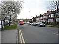
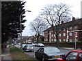
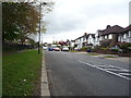
4
Waterfall Road
Looking down into the valley of Pymmes Brook. The road on the right is Ravenscraig Road and the one on the left is Ryhope Road.
Image: © Martin Addison
Taken: 25 Sep 2009
0.05 miles
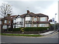
6
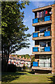
Homestead House and Brunswick Park Road
One of the blocks on a small estate beside Waterfall Road. The houses behind are on Brunswick Park Road.
Image: © Martin Addison
Taken: 25 Sep 2009
0.09 miles
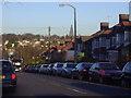
7
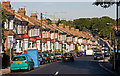
Brunswick Park Road
The road descends into a valley that was probably created by a tributary of Pymmes Brook - the stream on the North Middlesex Golf Course seems a likely candidate.
At the bottom it passes New Southgate Recreation Ground before climbing again to a summit beside New Southgate Cemetery, hidden in the trees on the horizon.
Image: © Martin Addison
Taken: 25 Sep 2009
0.11 miles
8
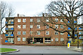
The Homestead 1 - 21
One of three identical blocks on this site.
Image: © Robin Webster
Taken: 25 Nov 2012
0.12 miles
10
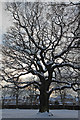
Snow Covered Oak Tree, Arnos Park, London N11
This is the section of the park west of the viaduct.
Image: © Christine Matthews
Taken: 21 Jan 2013
0.13 miles