IMAGES TAKEN NEAR TO
Brunswick Grove, LONDON, N11 1HN
Introduction
This page details the photographs taken nearby to Brunswick Grove, N11 1HN by members of the Geograph project.
The Geograph project started in 2005 with the aim of publishing, organising and preserving representative images for every square kilometre of Great Britain, Ireland and the Isle of Man.

There are currently over 7.5m images from over14,400 individuals and you can help contribute to the project by visiting https://www.geograph.org.uk
Image Map
Images are licensed for reuse under creativecommons.org/licenses/by-sa/2.0
Notes
- Clicking on the map will re-center to the selected point.
- The higher the marker number, the further away the image location is from the centre of the postcode.
Image Listing (68 Images Found)
Images are licensed for reuse under creativecommons.org/licenses/by-sa/2.0
Image
Details
Distance
1
Brunswick Avenue, London N11
As seen from the junction with Oakleigh Road South.
Image: © Christine Matthews
Taken: 29 Jan 2011
0.04 miles
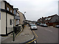
2
Oakleigh Road South, London N11
As seen from the corner of Brunswick Avenue.
Image: © Christine Matthews
Taken: 29 Jan 2011
0.04 miles
4
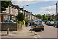
Brunswick Boyz
Three lads stroll along Brunswick Avenue during the school half term holiday. At the end of the road is Brunswick Park Road and New Southgate Cemetery.
Image: © Martin Addison
Taken: 28 May 2009
0.05 miles
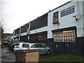
5
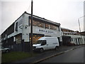
Bird and Davis on Brunswick Park Road
The building to the right is a dancing school.
Image: © David Howard
Taken: 18 Nov 2015
0.06 miles
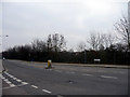
6
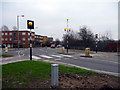
Pedestrian Crossing, Oakleigh Road North, London N11
As seen from the pavement adjacent to the railway bridge.
Image: © Christine Matthews
Taken: 29 Jan 2011
0.06 miles
7

Ordnance Survey Cut Mark
This OS cut mark can be found on the old warehouse type building on the south side of Brunswick Avenue. It marks a point 59.247m above mean sea level.
Image: © Adrian Dust
Taken: 2 Aug 2016
0.07 miles
8
North London Business Park, London N11
As seen from the Oakleigh Road North side.
Image: © Christine Matthews
Taken: 29 Jan 2011
0.08 miles
9
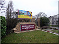
Entrance to North London Business Park
The park was once the Standard Telephones and Cables factory, in which one of my neighbours used to work. With the move away from electro-mechanical telecommunications equipment and loss of business following the privatisation of British Telecom, STC lost its way and was taken over by Nortel. A sad end to an innovative company that pioneered the use of optical fibre for telecommunications. The factory here had been rundown and closed by the end of the 1980's.
Image: © Martin Addison
Taken: 28 May 2009
0.08 miles
10
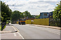
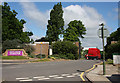
Oakleigh Road South
A skip lorry grinds its way up the hill leaving a cloud of dust and diesel fumes in its wake. It has just come out of Winter's skips, one of several businesses occupying the small industrial estate on the right, which is sandwiched between the road and the Kings Cross mainline. On the left, at the bottom of the hill, the New Southgate Recreation Ground is just visible.
Image: © Martin Addison
Taken: 28 May 2009
0.08 miles