IMAGES TAKEN NEAR TO
Brunswick Crescent, LONDON, N11 1EE
Introduction
This page details the photographs taken nearby to Brunswick Crescent, N11 1EE by members of the Geograph project.
The Geograph project started in 2005 with the aim of publishing, organising and preserving representative images for every square kilometre of Great Britain, Ireland and the Isle of Man.

There are currently over 7.5m images from over14,400 individuals and you can help contribute to the project by visiting https://www.geograph.org.uk
Image Map
Images are licensed for reuse under creativecommons.org/licenses/by-sa/2.0
Notes
- Clicking on the map will re-center to the selected point.
- The higher the marker number, the further away the image location is from the centre of the postcode.
Image Listing (72 Images Found)
Images are licensed for reuse under creativecommons.org/licenses/by-sa/2.0
Image
Details
Distance
1
Brunswick Boyz
Three lads stroll along Brunswick Avenue during the school half term holiday. At the end of the road is Brunswick Park Road and New Southgate Cemetery.
Image: © Martin Addison
Taken: 28 May 2009
0.06 miles
2
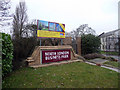
North London Business Park, London N11
As seen from the Oakleigh Road North side.
Image: © Christine Matthews
Taken: 29 Jan 2011
0.07 miles
3
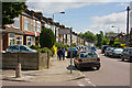
Brunswick Avenue, London N11
As seen from the junction with Oakleigh Road South.
Image: © Christine Matthews
Taken: 29 Jan 2011
0.08 miles
4
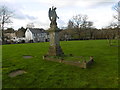
New Southgate Cemetery
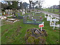
New Southgate Cemetery was formerly known as the Great Northern Cemetery. It was opened in 1861 and like Brookwood in Surrey it had its own railway line bringing coffins direct into the cemetery via a mile-long branch, leaving the main line out of King's Cross at what was then Colney Hatch station (now New Southgate). The branch had gone by the 1880s and there is virtually no sign of it today.
This is near the northern entrance. Brunswick Park Road is just ahead with Brunswick Crescent leading off it.
Image: © Marathon
Taken: 10 Feb 2016
0.08 miles
5
North London Business Park
This is the main entrance gates to the business park which used to be the Nortel site. The security barriers have now gone and the security cabin is unoccupied.
Image: © Nigel Mykura
Taken: 22 Dec 2008
0.09 miles
6
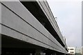
Car Park, North London Business Park
This concrete multi storey car park is part of the business park which used to be the Nortel site. It was built for Nortel Networks for their own occupation but during the construction period, they decided to relocate to Harlow and it now houses several smaller companies.
Image: © Nigel Mykura
Taken: 22 Dec 2008
0.09 miles
7
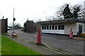
North London Business Park
This emergency support centre is located in the grounds of the business park which used to be the Nortel Telecommunications site.
Image: © Nigel Mykura
Taken: 22 Dec 2008
0.09 miles
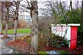
8

Ordnance Survey Cut Mark
This OS cut mark can be found on the old warehouse type building on the south side of Brunswick Avenue. It marks a point 59.247m above mean sea level.
Image: © Adrian Dust
Taken: 2 Aug 2016
0.09 miles
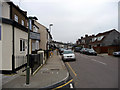
9
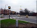
Pedestrian Crossing, Oakleigh Road North, London N11
As seen from the pavement adjacent to the railway bridge.
Image: © Christine Matthews
Taken: 29 Jan 2011
0.10 miles
10
New Southgate Cemetery
New Southgate Cemetery was formerly known as the Great Northern Cemetery. It was opened in 1861 and like Brookwood in Surrey it had its own railway line bringing coffins direct into the cemetery via a mile-long branch, leaving the main line out of King's Cross at what was then Colney Hatch station (now New Southgate). The branch had gone by the 1880s and there is virtually no sign of it today.
This is near the northern entrance. Brunswick Park Road is on the right.
Image: © Marathon
Taken: 10 Feb 2016
0.10 miles