IMAGES TAKEN NEAR TO
Maygood Street, LONDON, N1 0HF
Introduction
This page details the photographs taken nearby to Maygood Street, N1 0HF by members of the Geograph project.
The Geograph project started in 2005 with the aim of publishing, organising and preserving representative images for every square kilometre of Great Britain, Ireland and the Isle of Man.

There are currently over 7.5m images from over14,400 individuals and you can help contribute to the project by visiting https://www.geograph.org.uk
Image Map
Images are licensed for reuse under creativecommons.org/licenses/by-sa/2.0
Notes
- Clicking on the map will re-center to the selected point.
- The higher the marker number, the further away the image location is from the centre of the postcode.
Image Listing (394 Images Found)
Images are licensed for reuse under creativecommons.org/licenses/by-sa/2.0
Image
Details
Distance
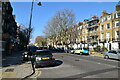
1
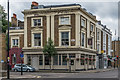
Little Georgia Public House, Corner of Dewey Road, London N1
Image: © Christine Matthews
Taken: 13 Oct 2016
0.02 miles
3
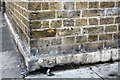
Benchmark on Job Centre Plus, Maygood Street
Ordnance Survey cut mark benchmark described on the Bench Mark Database at http://www.bench-marks.org.uk/bm39319
Image: © Roger Templeman
Taken: 27 Aug 2011
0.02 miles
4
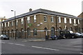
Job Centre Plus, Maygood Street
This is the junction of Maygood Street with Barnsbury Road. There is an OS benchmark Image on the corner of the building on the Maygood Street face.
Image: © Roger Templeman
Taken: 27 Aug 2011
0.02 miles
5
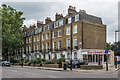
16 - 38 Barnsbury Road
Early 19th Century terrace. Grade II listed - see www.historicengland.org.uk/listing/the-list/list-entry/1195466.
Image: © Ian Capper
Taken: 13 Jul 2019
0.03 miles
6
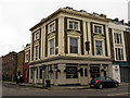
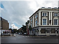
Little Georgia
A restaurant on the corner of Penton Street (foreground) and Dewey Road, Islington, which coincidentally is directly above the Grand Union Canal tunnel Image
The building is listed grade 2 (list entry number 1204593), described as a "Mid-C19 public house, formerly the White Conduit House". Later it was the Penny Farthing Pub Image The original name (White Conduit House) can still be made out at the top of the building.
Image: © Stephen Craven
Taken: 9 Mar 2013
0.03 miles
7
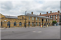
Job Centre Plus
Islington job centre in Barnsbury Road. The building first appears on the 1920 1:10,560 map (unnamed), replacing previous housing; its purpose is first shown on the 1953-4 1:1,250 map where it is marked as "Employment Exchange". In the background is the 1937-built Berners House on the Barnsbury Estate.
Image: © Ian Capper
Taken: 13 Jul 2019
0.04 miles
8
The Little Georgia
Georgian restaurant in a former pub at the corner of Dewey Road and Barnsbury Road. Originally a pub, listed as the White Conduit House Tavern in 1852. It later became the Penny Farthing (it still had that name in 2004), before being converted to an Italian restaurant, Punto Zero (the pubwiki website has a photo with that name in 2007). It then went through various other guises, including an Italian-Japaneses fusion called Tokyo Gino (a photo on Flickr shows it as that in 2009) and later a Sardinian restaurant called Tenore, before changing to its current role and name. Grade II listed - see www.historicengland.org.uk/listing/the-list/list-entry/1204593.
Image: © Ian Capper
Taken: 13 Jul 2019
0.04 miles
9
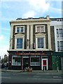
The Penny Farthing Pub - was White Conduit House.
I'm sure that someone knows the history of White Conduit House. I suspect a connection with the canal which runs underneath (see separate photo of tunnel plaque). This is on the corner of Dewey Road and Barnsbury Road.
Image: © Robin Hall
Taken: 21 Jan 2005
0.04 miles
10
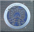
Islington Canal Tunnel plaque.
Plaque marking the presence of the canal beneath our feet.
Image: © Robin Hall
Taken: 21 Jan 2006
0.04 miles