IMAGES TAKEN NEAR TO
York Way, LONDON, N1 0AE
Introduction
This page details the photographs taken nearby to York Way, N1 0AE by members of the Geograph project.
The Geograph project started in 2005 with the aim of publishing, organising and preserving representative images for every square kilometre of Great Britain, Ireland and the Isle of Man.

There are currently over 7.5m images from over14,400 individuals and you can help contribute to the project by visiting https://www.geograph.org.uk
Image Map (Loading...)


Getting Data...Please wait
Leaflet Map data © OpenStreetMap
Images are licensed for reuse under creativecommons.org/licenses/by-sa/2.0
Notes
- Clicking on the map will re-center to the selected point.
- The higher the marker number, the further away the image location is from the centre of the postcode.
Image Listing (716 Images Found)
Images are licensed for reuse under creativecommons.org/licenses/by-sa/2.0
Image
Details
Distance
1
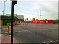
York Way, King's Cross
The development continues, apparently for eternity, although it took even longer for the plans to be agreed on, this has been brewing since the 80s and possibly earlier.
Image: © David Howard
Taken: 29 Aug 2012
0.03 miles
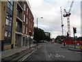
2
King's Cross development site
Although it has been ongoing for over a decade there is still work continuing on the redevelopment of the King's Cross railway land.
Image: © David Howard
Taken: 28 Aug 2014
0.03 miles
3
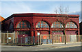
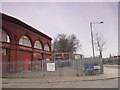
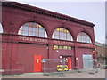
York Road Underground Station
York Road Station, near King's Cross is one of six disused London Underground stations designed by the architect Leslie Green (1875-1908), the others being Aldwych, Brompton Road, Down Street, Euston and South Kentish Town. York Road opened in 1906 and closed in 1932. The ox-blood red faience cladding characterizes Green's stations, and there are about 40 in all.
Other examples are:
Image]
Image]
Image]
Image]
Image]
Image]
Image
For a full account of the work of Leslie Green see Leboff, David: The Underground stations of Leslie Green. London: Capital Transport, 2002.
Image: © Jim Osley
Taken: 2 Feb 2014
0.04 miles
4
The (former) York Road tube station, York Way / Bingfield Street, N1 (2)
York Road station, between Kings’ Cross and Caledonian Road stations, opened in December 1906 at the corner of York Road (now York Way) and Bingfield Street. In 1909 the Piccadilly line decided to let some trains pass through some of the lesser-used stations without stopping; these included York Road. Sunday services were withdrawn in 1918 and the station was closed for public use in September 1932. The street level building became derelict, but was renovated in 1989 revealing the station’s name and the entrance and exit signs. With the massive redevelopment in the King’s Cross area, there is a possibility that the station might be re-opened - see http://en.wikipedia.org/wiki/York_Road_tube_station .
In the distance (right) is the clock tower on St. Pancras station - a view of it from the south is shown in Image
Image: © Mike Quinn
Taken: 9 Feb 2011
0.05 miles
5
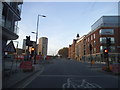
York Way at the junction of Copenhagen Street
Image: © David Howard
Taken: 31 Oct 2014
0.05 miles
6
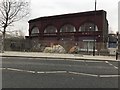
York Road Underground Station
The building that housed the York Road underground station, on the Piccadilly Line between Caledonian Road and Kings Cross St Pancras. The station was operational between 1906 and 1932.
Image: © Alistair Stewart
Taken: 19 Jan 2019
0.06 miles
7
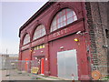
The (former) York Road tube station, York Way / Bingfield Street, N1 - west side (2)
York Road station, between Kings’ Cross and Caledonian Road stations, opened in December 1906 at the corner of York Road (now York Way) and Bingfield Street. In 1909 the Piccadilly line decided to let some trains pass through some of the lesser-used stations without stopping; these included York Road. Sunday services were withdrawn in 1918 and the station was closed for public use in September 1932. The street level building became derelict, but was renovated in 1989 revealing the station’s name and the entrance and exit signs. With the massive redevelopment in the King’s Cross area, there is a possibility that the station might be re-opened - see http://en.wikipedia.org/wiki/York_Road_tube_station .
Image: © Mike Quinn
Taken: 9 Feb 2011
0.06 miles
8
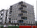
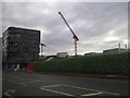
Arthouse, King's Cross
Part of a large development on the former railway warehouses. The apartments at the ArtHouse development are the first block of private homes for sale at King’s Cross on York Way.
Image: © David Anstiss
Taken: 10 Mar 2013
0.06 miles
9
The (former) York Road tube station, York Way / Bingfield Street, N1 - west side
York Road station, between Kings’ Cross and Caledonian Road stations, opened in December 1906 at the corner of York Road (now York Way) and Bingfield Street. In 1909 the Piccadilly line decided to let some trains pass through some of the lesser-used stations without stopping; these included York Road. Sunday services were withdrawn in 1918 and the station was closed for public use in September 1932. The street level building became derelict, but was renovated in 1989 revealing the station’s name and the entrance and exit signs. With the massive redevelopment in the King’s Cross area, there is a possibility that the station might be re-opened - see http://en.wikipedia.org/wiki/York_Road_tube_station .
Image: © Mike Quinn
Taken: 9 Feb 2011
0.06 miles