IMAGES TAKEN NEAR TO
Muswell Hill, LONDON, N10 3TH
Introduction
This page details the photographs taken nearby to Muswell Hill, N10 3TH by members of the Geograph project.
The Geograph project started in 2005 with the aim of publishing, organising and preserving representative images for every square kilometre of Great Britain, Ireland and the Isle of Man.

There are currently over 7.5m images from over14,400 individuals and you can help contribute to the project by visiting https://www.geograph.org.uk
Image Map (Loading...)


Getting Data...Please wait
Leaflet Map data © OpenStreetMap
Images are licensed for reuse under creativecommons.org/licenses/by-sa/2.0
Notes
- Clicking on the map will re-center to the selected point.
- The higher the marker number, the further away the image location is from the centre of the postcode.
Image Listing (101 Images Found)
Images are licensed for reuse under creativecommons.org/licenses/by-sa/2.0
Image
Details
Distance
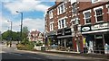
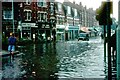
2
Flash flood in Park Road
A flash flood, caused by rainstorm run-off overwhelming drains, at the bottom of Muswell Hill at the junction with Park Road. The Victoria Stakes pub on the right.
Image: © E Gammie
Taken: 14 Aug 1982
0.01 miles
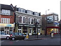
3
The Victoria Stakes
Bar / restaurant on Muswell Hill, London N10.
Image: © JThomas
Taken: 27 Jul 2019
0.01 miles
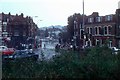
4
Flash flood, Park Road
A vehicle negotiating the flooding in Park Road at the junction with Muswell Hill. The drains had been unable to cope with the rapid run-off during a rainstorm.
Image: © E Gammie
Taken: 14 Aug 1982
0.01 miles
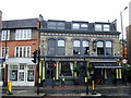
5
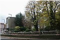
The lower end of Muswell Hill
Park Road is on the left
Image: © David Howard
Taken: 8 Nov 2020
0.01 miles
6
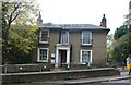
Old house at the bottom of Muswell Hill
Image: © David Howard
Taken: 8 Nov 2020
0.02 miles
7
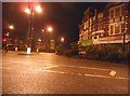
Park Road at the junction of Priory Road, Hornsey
Image: © David Howard
Taken: 3 Mar 2014
0.02 miles
8
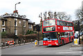
At The Bottom
The junction with Priory Road at the foot of Muswell Hill - the angle of the bus in relation to the perpendicular buildings beyond gives an indication of the steepness of the climb for vehicles and pedestrians going up to Muswell Hill Broadway.
The bus on the W7 route is a Dennis Trident with Plaxton President body. Its Cummins engine will need all of its 245hp on this route as it has to contend with Crouch Hill as well as Muswell Hill. The route, operated by Metroline, currently sees three different vehicle types. This is a TPL. also on the route are VPL's, externally the same - see Image and TE's - the same as the vehicle on the 210 route in Image
Image: © Martin Addison
Taken: 28 Jan 2011
0.02 miles
9
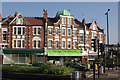
Priory Road, Hornsey
Shops on the corner of Priory Road and Park lane.
Image: © Stephen McKay
Taken: 6 Jun 2013
0.03 miles