IMAGES TAKEN NEAR TO
Muswell Hill Road, LONDON, N10 3JD
Introduction
This page details the photographs taken nearby to Muswell Hill Road, N10 3JD by members of the Geograph project.
The Geograph project started in 2005 with the aim of publishing, organising and preserving representative images for every square kilometre of Great Britain, Ireland and the Isle of Man.

There are currently over 7.5m images from over14,400 individuals and you can help contribute to the project by visiting https://www.geograph.org.uk
Image Map
Images are licensed for reuse under creativecommons.org/licenses/by-sa/2.0
Notes
- Clicking on the map will re-center to the selected point.
- The higher the marker number, the further away the image location is from the centre of the postcode.
Image Listing (96 Images Found)
Images are licensed for reuse under creativecommons.org/licenses/by-sa/2.0
Image
Details
Distance
1
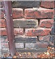
Ordnance Survey Cut Mark
This OS cut mark can be found on the wall between No120 & 122 Muswell Hill Road. It marks a point 96.532m above mean sea level.
Image: © Adrian Dust
Taken: 2 Aug 2016
0.03 miles
4
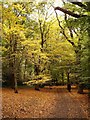
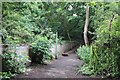
Highgate Wood in early April (2)
Highgate Wood is ancient woodland, with hornbeam, oak and holly reckoned to be the historically significant species. For centuries hornbeams were coppiced - periodically cut back to close to the ground - to provide a supply of wood for (among other uses) charcoal-burning. In the last twenty years a coppicing regime has been re-instated, for certain areas of the wood.
In this shot we are looking north along a path which runs roughly parallel to Muswell Hill Road on the east side of the site. To the left there are a number of tall oaks, while to the right the trees are predominantly hornbeam. Hornbeam leaves open early, so that in this early April shot the area to the right is noticeably greener.
The wood is owned and managed by the City of London Corporation.
Image: © Stefan Czapski
Taken: 6 Apr 2011
0.06 miles
7
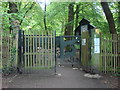
Highgate Wood, Bridge Gate entrance
With council imposed chicane stopping cyclists from using the wood a shame really as it would seem an appropriate route to use a bicycle.
Image: © Oxyman
Taken: 29 Apr 2009
0.08 miles
9
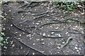
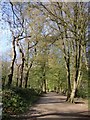
Tree roots on Queen's Wood, Muswell Hill
Image: © David Howard
Taken: 15 Jun 2019
0.08 miles
10
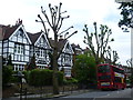
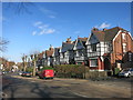
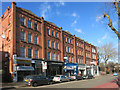
Houses in Muswell Hill Road
It is hard to put a date on these houses but I would guess some time between 1900 and the Second World War. They are close to the junction with Onslow Gardens.
Image: © Marathon
Taken: 17 Jun 2015
0.08 miles