IMAGES TAKEN NEAR TO
Beattock Rise, LONDON, N10 3DS
Introduction
This page details the photographs taken nearby to Beattock Rise, N10 3DS by members of the Geograph project.
The Geograph project started in 2005 with the aim of publishing, organising and preserving representative images for every square kilometre of Great Britain, Ireland and the Isle of Man.

There are currently over 7.5m images from over14,400 individuals and you can help contribute to the project by visiting https://www.geograph.org.uk
Image Map (Loading...)


Getting Data...Please wait
Leaflet Map data © OpenStreetMap
Images are licensed for reuse under creativecommons.org/licenses/by-sa/2.0
Notes
- Clicking on the map will re-center to the selected point.
- The higher the marker number, the further away the image location is from the centre of the postcode.
Image Listing (212 Images Found)
Images are licensed for reuse under creativecommons.org/licenses/by-sa/2.0
Image
Details
Distance
1
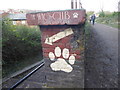
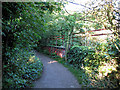
You see posher businesses in Muswell Hill
This is on the Parkland Walk, just as St James's Lane Viaduct is reached.
The Parkland Walk is the former track of the branch railway line which ran from Finsbury Park to Alexandra Palace and closed to passengers in 1954 and finally in 1971. The Parkland Walk officially opened in 1984.
Image: © Marathon
Taken: 11 Mar 2019
0.01 miles
2
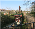
Steps up to the Viaduct
Access onto the old Alexandra Park rail track, now a cycleway.
Image: © Des Blenkinsopp
Taken: 17 Mar 2016
0.01 miles
4
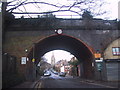
St james's Lane through the old viaduct
Image: © Sarah Charlesworth
Taken: 12 Jan 2014
0.03 miles
5
Alexandra Palace Branch Viaduct
Looking towards Cranley Gardens Station from the viaduct over St.James's Lane, Muswell Hill. The viaduct has a gentle curve in the opposite direction to that of the Parkland Walk in the photo - which meanders from one side of the double track viaduct to the other.
Image: © Martin Addison
Taken: 22 May 2007
0.05 miles
6
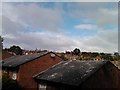
View of Highgate Village from Parkland Walk North
Parkland Walk is a nature trail, designated as a nature reserve in 1990, following the route of a railway line which used to run from Highgate to Alexandra Palace. The line closed in 1982. This view of Highgate Village was taken from the northern end of Parkland Walk, which starts at Cranley Gardens and leads into Alexandra Park, looking west-northwest.
Image: © Robert Lamb
Taken: 26 Sep 2010
0.05 miles
8

View from St James's Lane Viaduct
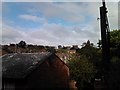
This is the view across London from St James's Lane Viaduct on the Parkland Walk. Storm Freya had cleared the air. The ArcelorMittal Orbit Tower and the buildings around Stratford are in the centre.
The Parkland Walk is the former track of the branch railway line which ran from Finsbury Park to Alexandra Palace and closed to passengers in 1954 and finally in 1971. The Parkland Walk officially opened in 1984.
The first part of the Parkland Walk goes from Finsbury Park to Archway Road. The old track of the railway then passes through Highgate Wood before it is rejoined at Muswell Hill Road and heads to Alexandra Palace across St James's Lane Viaduct.
Image: © Marathon
Taken: 11 Mar 2019
0.06 miles
9
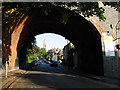
St.James's Lane
Looking through an arch of the disused Alexandra Palace Branch viaduct towards St.James church, Muswell Hill.
Image: © Martin Addison
Taken: 22 May 2007
0.06 miles
10
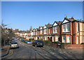
View of Highgate Village from Parkland Walk North #2
This is a pan west of Image, looking north.
Image: © Robert Lamb
Taken: 26 Sep 2010
0.06 miles