IMAGES TAKEN NEAR TO
Wood Vale, LONDON, N10 3DN
Introduction
This page details the photographs taken nearby to Wood Vale, N10 3DN by members of the Geograph project.
The Geograph project started in 2005 with the aim of publishing, organising and preserving representative images for every square kilometre of Great Britain, Ireland and the Isle of Man.

There are currently over 7.5m images from over14,400 individuals and you can help contribute to the project by visiting https://www.geograph.org.uk
Image Map
Images are licensed for reuse under creativecommons.org/licenses/by-sa/2.0
Notes
- Clicking on the map will re-center to the selected point.
- The higher the marker number, the further away the image location is from the centre of the postcode.
Image Listing (84 Images Found)
Images are licensed for reuse under creativecommons.org/licenses/by-sa/2.0
Image
Details
Distance
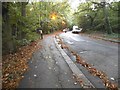
4
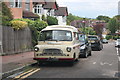
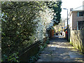
Bedford Van on Wood Vale, Muswell Hill
Image: © David Howard
Taken: 15 Jun 2019
0.09 miles
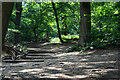
5
Greenways
A very straight path from Park Road to Wood Vale ahead and across into Queen's Wood.
Image: © Robin Webster
Taken: 19 Mar 2011
0.10 miles
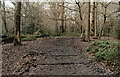
6
Muswell Hill : stepped path, Queen's Wood
Image: © Jim Osley
Taken: 20 Jul 2021
0.11 miles
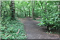
10
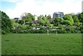
Crouch End Open Space
Beyond are allotments and blocks of flats on Shepherd's Hill.
Image: © Jim Osley
Taken: 1 May 2020
0.13 miles